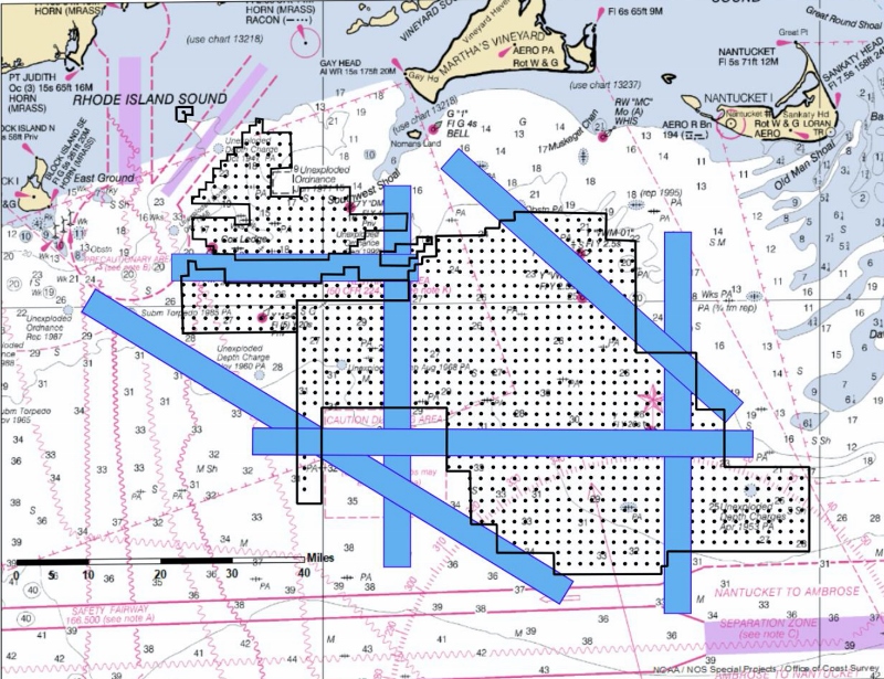
A coalition of commercial fishing groups is calling for four-mile-wide transit lanes through offshore wind turbine arrays off New England, as federal ocean planners and the Coast Guard consider maritime safety aspects of the projects.
In a Jan. 3 letter to those agencies, the Responsible Offshore Development Alliance proposed six vessel traffic lanes – each four nautical miles wide and up to 70 miles long – through wind turbine areas proposed by energy companies south of Martha’s Vineyard and Nantucket off Massachusetts.
Without endorsing that spacing – opposed by Rhode Island squid fishermen and others who say they cannot not work amid such arrays – the alliance letter is a counter-proposal that superimposes transit lanes on the developers’ plan.
“The proposal presented here utilizes the uniform 1x1 nm spaced turbines presented in the Nov. 1 proposal and includes transit lanes of adequate widths to preserve safe and efficient passage along the routes most often used by fishermen,” the letter states.
A chart graphic submitted along with the letter to BOEM, the Coast Guard and NOAA, resembles an earlier conceptual design circulated by RODA in fall 2018. As BOEM was preparing another round of New England lease offerings in late 2018, it included that early version as “this kind of buyer beware notice,” advising wind developers their plans would need to include transit lanes, recalled Annie Hawkins, executive director of the alliance.
“It was a huge win at the time. It seemed like they were taking this seriously,” said Hawkins. But the new round of leases proceeded, followed by states entering power purchase agreements for planned developments, without enough progress on negotiating layout plans among the developers, fishermen and agencies, she added.
The alliance picked up where other New England working groups had tried, with new workshops. “The fishermen have been very, very consistent in these meetings that they (transit corridors) need to be four miles,” said Hawkins.
As portrayed in the updated graphic, fishermen think the wide lanes will be safer both in allowing adequate seaway for vessels passing through the arrays, particularly in heavy weather. There is also hope that wide corridors will help mitigate radar interference from rotating turbine blades, an issue that has yet to be fully investigated, said Hawkins.
The new map also adds lanes to afford shorter passages through the eastern side of the planned turbine fields. That would afford shorter transit times in bad weather and for crews working on time-constrained fisheries, such as groundfish days at sea and day bot scallops, according to the alliance.
“Some of these lanes are going to be 50 or 70 miles,” said Hawkins.
The Coast Guard’s own study of how the southern New England wind projects and their safety considerations had been projected to be ready in draft form by late 2019, but the service has now been assessing the wind developers’ layout proposal. That helped spur the fishermen’s alliance to put together its own formal proposal, said Hawkins.
The fishermen’s proposal includes a caveat: none of its features should be considered as setting precedents for the future design of other wind turbine projects outside of southern New England.
Likewise, fishing advocates make no endorsement of the developers’ one nautical mile layout plan.
“RODA reiterates, consistent with each of our previous comments on the record, that most fishing vessels will not be able to operate in this array and significant displacement will still occur due to 1 nm spacing,” the letter states. “A comprehensive and inclusive mitigation plan will be necessary to account for these impacts.
“The proposed layouts also do not account for effects to ecosystem and resource distribution, nor have these effects been sufficiently nor comprehensively analyzed to date,” the letter says, calling for expanded research and monitoring to study impacts of offshore energy projects.
“The question of whether you can fish in an array,” Hawkins said, “is an entirely different matter.”


