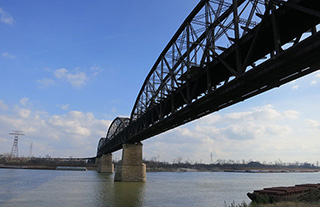
The Coast Guard has closed a portion of the Upper Mississippi River near St. Louis to all vessel traffic due to extremely high water levels and fast currents.
The closure, between mile markers 184 and 179 near MacArthur Bridge, follows heavy rain around the central U.S. that has the Mississippi at or near flood stage in several locations.
Capt. Martin Malloy, Upper Mississippi River Captain of the Port, ordered the closure under a waterways action plan, intended to provide the marine industry, Coast Guard, U.S. Army Corps of Engineers, and state and local governments with a plan for facilitating the safe and orderly movement of traffic during extreme conditions on the inland rivers.
“Our foremost concerns are safety of life and navigation, protection of infrastructure and property, and to prevent marine casualties,” said Cmdr. Ryan Rhodes, deputy commander, Sector Upper Mississippi River.
On Wednesday, the Coast Guard established a safety zone and restricted traffic on the Upper Mississippi between mile marker 110 near Chester, Ill. and mile marker 34 near Billings Landing, Mo., to ensure that passing marine traffic does not put additional pressure on the Federal Levee Systems while the U.S. Army Corps of Engineers performs flood control missions.
Restrictions to operations will be lifted as soon as conditions improve, the Coast Guard said. The safety zone and restricted traffic order between mile marker 110 and mile marker 34 is expected to remain in effect through Jan. 3, 2016, but may be reevaluated based on changing river conditions.


