


Based on changes to the current and forecasted conditions the U.S. Army Corps of Engineers began opening the Bonnet Carré Spillway Friday due to high water in the Mississippi River that threatens New Orleans and the surrounding region. High water is also a danger to marine traffic in the river.
Plans were to reopen the spillway May 14, but regional rainfall caused the Mississippi River to rise six inches in a 24-hour period with more rain expected through the weekend. These rains could elevate the Mississippi River above 17' with a peak as high as 17.5' at the Carrollton Gage.
In what the Corps called an “abundance of caution,” the operation date was moved forward to ensure the safe passage of the high water by limiting the elevations downriver of the spillway. The spillway was opened earlier this year from Feb. 27 until April 11.
This will be the 14th operation of the structure since 1937 and the first time it has been opened twice during the same high-water event. Operation of the structure will relieve pressure on main levees, maintain river stages, and regulate the flow downriver from the spillway. The decision to open Bonnet Carré was issued by Maj. Gen. Richard G. Kaiser commander of the Mississippi Valley Division in Vicksburg, Miss.
“Environmental, hydrologic, structural, and navigational considerations all bear on the decision to open Bonnet Carré,” the Corps said in a statement released on Friday. “Other factors that affect the decision are the overall condition of the levees and the ability of the river to pass flows, and the effects high water and river currents may have on vessels navigating the river. The Corps has a detailed environmental monitoring plan in place that will assess water quality, dissolved oxygen, sedimentation, recreation, and natural resources such as the pallid sturgeon, both within the spillway as well as Lake Pontchartrain.”
The Bonnet Carré Spillway, located 28 miles above New Orleans, is a vital element of the multi-state Mississippi River and Tributaries (MR&T) system, which uses a variety of features to provide flood risk reduction to the alluvial Mississippi Valley from Cape Girardeau, Mo., to Head of Passes, La. Located on the east bank in St. Charles Parish, it can divert a portion of the river’s floodwaters via Lake Pontchartrain into the Gulf of Mexico, thus allowing high water to bypass New Orleans and other nearby river communities. The structure has a design capacity of 250,000 cfs, the equivalent of roughly 1,870,000 gallons per second.
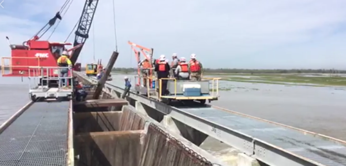
The structure consists of a control structure and a floodway. The control structure is a concrete weir that parallels the river for a mile and a half. It consists of 350 gated bays, each holding 20 timber “needles,” for a total of 7,000 needles. When needles are removed, river water flows into the floodway and is conveyed nearly six miles between guide levees to the lake. Operation of the structure is relatively simple. Two cranes, moving on tracks atop the structure, lift timbers from their vertical position in the weir and set them horizontally across the top of the structure to allow river water into the spillway.
The present conditions and updated forecasts indicate the river will stay at the 16.9' stage until June 3, 2019 before beginning a slow fall. The Corps said a crest above the spillway will occur between May 21 and May 23, the stages below the structure will be artificially controlled by flow diverted through the open flood control structure.