


After hovering around its 17’ flood stage at New Orleans for much of January, the Mississippi River this week is back in bounds, down to around 11' after weeks of wild mishaps.
A tricky bend in the river at Vicksburg, Miss., bridges claimed a series of barge tows, and the season was capped when an empty oil tanker lost control and bounced off a city water intake and old pier in New Orleans.
Born of heavy rain systems generated by the El Niño warm-water trend in the Pacific, the unusual winter floods came after high and fast water from March into summer 2015 that led to its own chain of accidents, and likewise ended with big slugs of sediment in the lower river.
By Jan. 14 the Associated Branch Pilots of the Port of New Orleans reduced allowable draft of vessels from 47’ to 43’, and two weeks later reduced it again to 41’ to ensure ships could make it through shoaled passes.
At Miller City, a farming community a few miles up the Mississippi from its confluence with the Ohio River, the Corps of Engineers and Illinois authorities continue to deal with a levee that breached Jan. 2. Besides flooding farmland for weeks, there is worry about navigation if the flow continues.
“With this El Niño year, we’ve had all of this rain that would usually be snow,” said Greg Raimondo, a Corps spokesman. Soils already saturated by earlier storms shed all that water when the next rounds rolled across the river basins in December, he said.
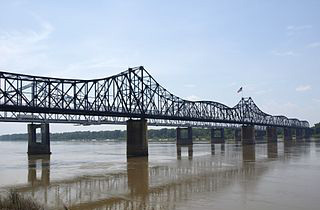
The river was below stages seen in the 2011 and 2008 floods, but “at Vicksburg it was a top 10 stage event” that peaked at 50.2’ – all the more remarkable for being the highest winter stage since February 1937 when it was 53.2’, said Tim Rodgers, a hydraulic engineer with the Corps of Engineers Vicksburg (Miss.) district.
River volumes up to 1.8 million cu. ft. per second made the Vicksburg bridges more treacherous.
“Going downstream, the river makes a really sharp right-hand turn there, plus you have (flow from) the Yazoo River Diversion Canal,” Raimondo said. While shipping was disrupted, “we weren’t at a point where we were pushing all that grain down the river. There was some, but it wasn’t like August, September, October.”
For operators, the fast water meant “smaller tows, slower tows, more power,” said Brent Dibner, president of Dibner Maritime Associates LLC, Chestnut Hill, Mass. “For the carriers, this shows up as higher costs and lower revenue.”
But compared to other high-water events there was less impact on grain shipments, Dibner said.
“We had a mild harvest season where rates did not explode as they did last season,” he said. “The market had already accomplished the goal of moving most of the grain out into silos and fleeting operations.”
The respite of these last couple weeks may only be temporary. In a Feb. 18 update, the National Weather Service cautioned that conditions in the upper river basins are primed for more flooding if heavy spring rains come.
“Wet conditions in the late fall and early winter periods have led to above normal stream flows and nearly saturated soils, which are the leading factors for the increased risk for spring flooding in 2016. With nearly saturated soils, almost all snow cover and any rainfall will turn into runoff this spring, rather than soaking into the soils.
“In addition, with rivers already running high, it will take less runoff to reach flood stages.”