


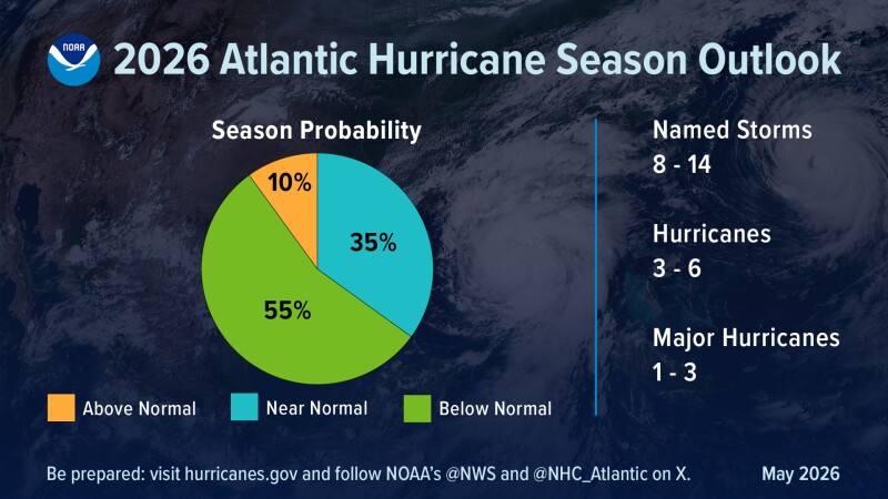
National Weather Service forecasters predict below-normal hurricane activity in the Atlantic basin during this year’s season that began June 1 and runs through Nov. 30.
In a summary, the weather service predicts a 35% chance of a “near-normal season, a 10% chance of an above-normal season, and a 55% chance of a below-normal season.”
In all the National Oceanic and Atmospheric Administration projects there will be a total 8 to 14 named storms (crossing the threshold of 39 mph or stronger winds).
Of those, 3-6 are forecast to become hurricanes with winds hitting winds 74 mph or higher – including 1-3 “major hurricanes” with winds of 111 mph or higher.
NOAA is calling a 70% confidence in these ranges. An average season has 14 named storms with seven hurricanes, including three major hurricanes.
In the months leading up to the 2026 season much attention has focused on a so-called “super El Niño” climate pattern emergent in the Pacific basins. During El Niño years, trade winds weaken and Pacific warm water is pushed eastward toward the west coast of the Americas.
That’s just one of competing influences on hurricane formation. This year’s “El Niño is expected to develop and intensify during the hurricane season, while ocean temperatures in the Atlantic are expected to be slightly warmer than normal and trade winds are likely weaker than average,” according to NOAA.
Those El Niño conditions tend to support less tropical storms and hurricanes, while warmer ocean temperatures and low winds support a more active year.
“Although El Niño’s impact in the Atlantic Basin can often suppress hurricane development, there is still uncertainty in how each season will unfold,” said Ken Graham, the National Weather Service director Ken Graham. “That is why it’s essential to review your hurricane preparedness plan now. It only takes one storm to make for a very bad season.”
Because the agency’s annual outlook describes overall seasonal activity based on large-scale weather and climate patterns, it cannot offer probabilities for when or where indicate where or when storms will affect land.
“The outlook is not a landfall forecast” is frequently stressed by forecasters and emergency response planners.
“Preparing now for hurricane season — and not waiting for a storm to threaten — is essential for staying ahead of any storm,” said Graham. Public websites weather.gov/safety and Ready.gov offer detailed information for how people can prepare.
NOAA Administrator Neil Jacobs said his agency’s “rapid integration of advanced technology, including AI-based weather models, drones, and next-generation satellite data will deliver actionable science to safeguard the lives and livelihoods of the American people.”
NOAA rolled out new online and communication resources for this season:
- NOAA’s National Hurricane Center (NHC) will implement an improved version of the tropical cyclone forecast cone graphic that will now include tropical storm and hurricane watches and warnings for inland areas for the continental United States, Hawaii, Puerto Rico and the U.S. Virgin Islands.
- NHC will begin testing an experimental version of the tropical cyclone track forecast cone that will capture a greater range of possibilities for the track of the storm by incorporating uncertainties for both direction of movement and timing.
- For the Hawaiian islands, NHC will provide new products and services for to include storm surge watches and warnings, and a peak storm surge graphic. These will be publicly available for the main Hawaiian Islands on hurricanes.gov.
- NOAA, in collaboration with the Unified Forecast System community, is testing an experimental high-resolution Seasonal Forecast System that utilizes the latest modeling technology and new methods to assess the evolution of the global ocean-atmosphere system. The system is helping forecasters better simulate tropical storms and hurricanes, and more effectively predict the number of hurricanes and major hurricanes.
- NOAA’s Atlantic Oceanographic and Meteorological Laboratory (AOML) is using machine learning to quality-control data collected from tail Doppler radar — a specialized radar system mounted on the back of NOAA’s “Hurricane Hunter” aircraft. This new method gathers more than 25% more meteorological data than the current method and leads to more high-quality data to support structure and wind analysis by forecasters.
New technologies for flood water prediction, rainfall totals and hurricane intensity forecasts.
- NOAA’s Office of Water Prediction high-resolution Flood Inundation Mapping (FIM) services provide emergency managers visualizations of those streets and neighborhoods likely to go underwater. FIM covers 60% of the U.S. population and will expand to nearly 100% by late September 2026.
- For the first time, data from small uncrewed aircraft systems (sUAS) will be integrated into NOAA’s hurricane forecast model during the 2026 hurricane season. Scientists from the Cooperative Institute for Marine and Atmospheric Studies (CIMAS) and NOAA’s Atlantic Oceanographic and Meteorological Laboratory (AOML) determined that incorporating sUAS data into NOAA’s Hurricane Analysis and Forecast System (HAFS) can improve hurricane intensity forecast accuracy by 10%.
- NOAA’s Weather Prediction Center launched the experimental Urban Rain Rate Dashboard, a customizable, real-time tool that shows the probability of extreme rainfall a week in advance for more than 60 U.S. cities.
NOAA also issued seasonal hurricane outlooks for the eastern Pacific and central Pacific hurricane basins, with both anticipated to have active seasons. The 2026 Atlantic seasonal outlook will be updated in early August, ahead of the historical peak of the season, which typically extends from mid-September through October.