


To enhance the monitoring of large and destructive hurricanes in the Atlantic Ocean, the National Oceanic and Atmospheric Administration (NOAA) has partnered with Saildrone Inc. to deploy a fleet of specialized nautical drones.
The collaboration will involve the deployment of a dozen 23' Saildrone Explorers, marking the largest mission undertaken by the company. The unmanned vessels will navigate the Atlantic Ocean and the Gulf of Mexico, providing valuable insights into the movements and intensification of storms.
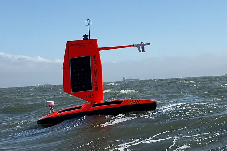
The Saildrone Explorers are propelled by wind and powered by solar energy, ensuring a zero operational carbon footprint. The company has also developed a sturdy, shorter wing design capable of withstanding wind speeds over 75 mph and large breaking waves. Equipped with various sensors, these saildrones will gather crucial oceanic data such as air temperature, humidity, barometric pressure, wind speed and direction, water temperature and salinity, sea surface temperature, and wave height and period.
Saildrone has been supporting NOAA's hurricane research for three years through the use of their uncrewed surface vehicles (USVs). By studying the rapid intensification of tropical storms into major hurricanes, the USVs aim to improve the understanding of this phenomenon. The data collected by Saildrone and other uncrewed systems utilized by NOAA will contribute to more accurate forecasts and earlier warnings for coastal communities.
“Rapid intensification, when hurricane winds strengthen by 35 mph or more in a matter of hours, can be a serious threat to coastal communities. The data provided by Saildrone and the other uncrewed systems that NOAA is using will help us better understand the physical forces that drive hurricanes, with the goal of more accurate forecasts and earlier warnings for communities,” NOAA scientist Greg Foltz said in a statement.
Saildrone's patented propulsion system, developed through a decade-long research endeavor in high-performance land sailing, is comprised of a hard wing, a longitudinal spar, and a vertical tail trim tab on the tail that adjusts the wing angle to the wind. The Saildrone wing technology enables missions lasting up to 12 months, eliminating the need for land-based maintenance, or refueling. Saildrone USVs travel at an average speed ranging from two to six knots, harnessing wind power, and are capable of reaching most ocean locations within 30 days from the nearest shore.
Shore-based human pilots supervise Saildrone USVs via satellite, while the vehicles autonomously navigate from one predetermined waypoint to another, accounting for wind and currents, and adhering to a user-defined safety corridor. Each USV is equipped with safety features, including an automatic identification system (AIS) transceiver, navigation lights, radar reflector, high-visibility wing colors, and onboard cameras, further ensuring secure operations. Saildrone’s technology fleet consists of three USVs: the Explorer, Voyager, and Surveyor.
The first 10 drones are being deployed from strategic locations including St. Thomas, U.S. Virgin Islands; St. Petersburg, Fla.; and Charleston, S.C. Additionally, two vehicles will remain onshore in case of an approaching hurricane.
Saildrone founder and CEO, Stephen Jenkins, told the KDFW FOX 4 News that the increased number of vehicles deployed allows Saildrone to gather more comprehensive data, benefiting not only hurricane forecasting but also addressing other maritime challenges such as illegal fishing, safety of life at sea, and navigation safety.
Experts from Colorado State University have recently revised their outlook for the 2023 Atlantic hurricane season, anticipating above-average activity. The updated forecast predicts 18 named storms, nine hurricanes, and four major hurricanes with winds exceeding 115 mph.