


Fishermen and mariners in the Gulf of Maine should keep an eye out for small robotic sailboats, soon to be cruising those waters to collect “high-resolution seafloor bathymetry and backscatter data along predetermined survey tracklines” for the National Oceanic and Atmospheric Administration.
Two autonomous, wind-propelled surface vehicles, colored high-visibility bright orange, will be operating in the gulf from Aug. 28 through Oct. 18, according to an advisory from the New England Fishery Management Council.
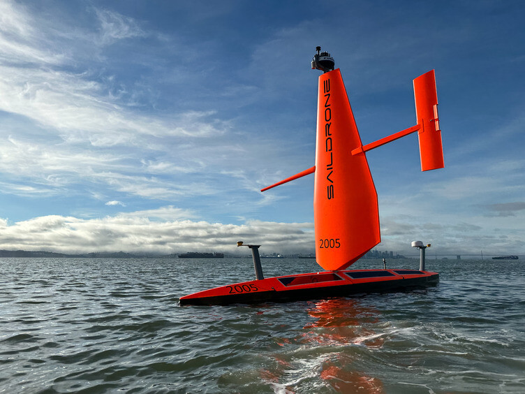
The 23-foot Saildrone Voyager vehicles, operated by Alameda, Calif., based Saildrone, operate independently 24/7 using wind and solar power to cruise at 2 to 4 knots along pre-determined waypoints, monitored via satellite links remotely by Saildrone’s onshore controllers. They are equipped with Automatic Identification System transponders, navigation lights, radar reflectors and cameras.
The National Marine Fisheries Service asked the asked the New England Fishery Management Council to help inform fishermen about the presence of these uncrewed surface vehicles (USVs) to help prevent interactions with fishing gear. Charts and survey coordinates are available online in this flyer.
“Fishing vessel operators who use fixed gears should avoid setting gear in areas planned for survey to help limit any risk of entanglement between the Saildrone Voyagers’ sound velocity profile casts and vertical lines,”
“Vessels are requested to transit the (eastern Gulf of Maine survey) area with caution and remain greater than 500 meters away from the USVs.”
Saildrone vehicles were a big assist to NMFS during Covid-19 in 2020, enabling the agency’s Alaska Fisheries Science Center to conduct a pollock survey while covid precautions prevented traditional at-sea survey methods.
NOAA has heavily invested in Saildrone’s fleet for hurricane research and monitoring, with a recent deployment of a dozen 23' Saildrone Explorers, marking the largest mission undertaken by the company. The unmanned vehicles will navigate the Atlantic Ocean and the Gulf of Mexico, providing valuable insights into the movements and intensification of storms.
The company has also developed a sturdy, shorter wing design capable of withstanding wind speeds over 75 mph and large breaking waves. Equipped with various sensors, the Saildrones gather data on air temperature, humidity, barometric pressure, wind speed and direction, water temperature and salinity, sea surface temperature, and wave height and period.
By studying the rapid intensification of tropical storms into major hurricanes, NOAA foresees Saildrone data can help understand how that happens, and help the agency produce more accurate forecasts and earlier warnings for coastal communities.
Saildrone's vessels use a patented propulsion system comprised of a hard wing, a longitudinal spar, and a vertical tail trim tab on the tail that adjusts the wing angle to the wind. The company says its wing technology enables missions lasting up to 12 months, eliminating the need for land-based maintenance, or refueling.