


Extraordinary flooding along the Mississippi River and its tributaries along with spring runoff of snow and ice have forced the Corps of Engineers to open the Morganza Spillway for only the third time in its 65-year history. The Corps could start opening the structure’s gates as early as June 2.
The purpose of the Morganza Floodway is to divert excess floodwater from the Mississippi River into the Atchafalaya Basin. The floodway consists of two structures — the Morganza Control Structure and the Morganza Floodway — which are designed to pass up to 600,000-cu.-ft.-per-second (cfs) of water to the Gulf of Mexico, alleviating stress for mainline levees downstream along the Mississippi River.
The Corps said the structure would be overtopped by June 5 if the gates are not opened. It will take about three days to open Morganza, diverting water through the spillway and into the floodway.
This is only the third time the structure has been opened since it was completed in 1954. The other years were 1973 and 2011.
Located at river mile 280 in central Louisiana, the Morganza Floodway begins at the Mississippi River, extends southward to the East Atchafalaya River levee, and eventually joins the Atchafalaya River Basin Floodway near Krotz Springs, La. Seven design plans were originally proposed, and a two-structure design was selected. Construction of both structures was completed in 1954. The first component at Morganza is the floodway. At 20 miles long and five miles wide, it consists of a stilling basin, an approach and outlet channel, and two guide levees. The second element is a control structure containing a concrete weir, two sluice gates, 17 scour indicators, and 125 gated openings.
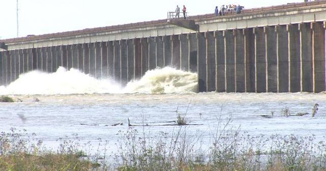
The Corps already has the Bonnet Carré Spillway open. It’s the second time that structure has been opened this year, the first time that’s happened in the spillway’s history. It’s also the first time Bonnet Carré has had to be opened in consecutive years.
The Bonnet Carré Spillway, located 28 miles above New Orleans, is part of the multi-state Mississippi River and Tributaries (MR&T) system, which uses a variety of features to provide flood risk reduction to the alluvial Mississippi Valley from Cape Girardeau, Mo., to Head of Passes, La. Located on the east bank in St. Charles Parish, it can divert a portion of the river’s floodwaters via Lake Pontchartrain into the Gulf of Mexico, thus allowing high water to bypass New Orleans and other nearby river communities. The structure has a design capacity of 250,000 cfs, the equivalent of roughly 1,870,000 gallons per second.
The structure consists of a control structure and a floodway. The control structure is a concrete weir that parallels the river for a mile and a half. It consists of 350 gated bays, each holding 20 timber “needles,” for a total of 7,000 needles. When needles are removed, river water flows into the floodway and is conveyed nearly six miles between guide levees to the lake. Operation of the structure is relatively simple. Two cranes, moving on tracks atop the structure, lift timbers from their vertical position in the weir and set them horizontally across the top of the structure to allow river water into the spillway.
No word yet on how long the spillways will remain open.