


By Nick Marathon and Matt Chang, USDA
During the first quarter, less-than-ideal navigation conditions have affected the barge industry, including ice accumulations and both low and high water conditions, the U.S. Department of Agriculture reported today in its weekly Grain Transportation Report. Year-to-date grain barge shipments are 35% lower than last year and 18% lower than the five-year average. (Grain barge shipments for this USDA analysis are the sum of the weekly downbound grain barge shipments through the locking portions of the Mississippi, Ohio, and Arkansas rivers.)
Barge freight rates were relatively steady for most of the first quarter. However, the recent high water events slowed barge logist ics, tightening the barge supply while raising spot rates. As of March 13, barge spot rates for export grain at major origin locations increased 46% to 62% in the last two weeks. For example, on March 13, the spot barge rate for export grain at St. Louis was 458% of tariff ($18.27 per ton), 54% higher than 297 percent of tariff ($11.85 per ton) reported on Feb. 27. The current rates are at levels not seen since early October 2017, during the corn and soybean harvest.
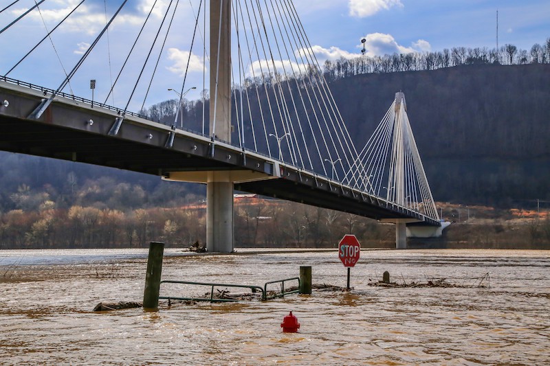
During the first half of February, stretches along the Mississippi River System faced low water conditions, as portions of Iowa, Missouri, and Illinois experienced moderate to severe drought conditions. However, river conditions drastically changed during the last half of February when persistent rains fell from the middle to lower Mississippi River Valley, eastward to the Ohio River Valley. This sparked flash flooding and pushed creeks and streams out of their banks, bringing extensive flooding to major rivers in the area. By Feb. 25, the Ohio River between Cincinnati and Evansville, Ind., reached its highest water level since March 1997. At the same time, high water events also occurred on the Illinois and Lower Mississippi rivers. The high water created hazardous navigation conditions on both rivers that, in some cases, temporarily closed a few locks and dams operated by the Army Corps of Engineers or required restricted barge operations. Navigational restrictions, such as daylight only movements, are set by the Waterway Action Plan, which is a joint effort of the U.S. Coast Guard, Corps, and senior leaders of the towing industry.
Following is a brief description of river conditions at various locations.
Ohio River: During the flooding peak, several locks on the Ohio River were closed. However, by March 12, all locks closed by high flows were reopened. The last lock to reopen was Smithland Lock and Dam (L&D). The Ohio River level at Cairo, Ill., where the Ohio River flows into the Mississippi River, crested at 54.8 feet on March 3. River levels are forecast to remain above flood stage until March 18. (The word “crest” is defined as the highest stage or level of a flood wave as it passes a particular point of high water level and stops rising.) The 54.8- foot crest was the 10th highest on record for Cairo, with the highest being 61.7 feet on May 2, 2011.
Illinois River: As of March 14, normal operating conditions are returning to most of the Illinois River. The Illinois River at LaGrange Lock and Dam crested at 26 feet on March 7. This was about nine feet short of the record crest of 35 feet set on July 2, 2015. Upcoming scheduled repairs will close LaGrange Lock from March 23 to March 28, and from April 2 to April 6.
Upper Mississippi River: Rain events have not affected the Upper Mississippi River since considerable portions of the river are closed during the winter. There has been a gradual northward opening of the river as temperatures rise ice accumulations melt. As of March 14, the northernmost report of barge traffic on the Mississippi River is at Lock and Dam 10, near Dubuque, Iowa.
Lower Mississippi River: Most of the high water issues for the central U.S. have abated and moved southward to the Lower Mississippi River, causing high water conditions. There are no locks on the Lower Mississippi River, which typically allows barge tows of 30 to 40 barges compared with 15 or less on the Upper Mississippi. However, with the current high water conditions on the Lower Mississippi River, barge companies have reduced tow sizes to 25 to 30 barges. In addition, based on the Waterway Action Plan, the Coast Guard is now only allowing southbound barge movements during daylight hours through Memphis, Tenn., Vicksburg, Miss., and Baton Rouge, La. Some industry sources suggest that this may persist for the remainder of March.
Nick Marathon and Matt Chang specialize in barge transportation at the USDA. Contact them at: [email protected], [email protected]