


As people moved into the Pacific Northwest, communities grew around the rivers, especially the Columbia and Snake rivers. Back then, the rivers were temperamental and hard to navigate. However, there was a vision to create a river highway, one that would allow barges to carry cargo from the Pacific Ocean to the confluence of the Snake and Clearwater rivers, 465 miles inland.
When the Walla Walla District was established in 1948, the Army Corps of Engineers entrusted the district with the completion of this vision. The district would need to construct a series of dams to achieve this.
ROLL ON COLUMBIA
The Columbia River is one of the largest rivers in North America and has been used as a thoroughfare for generations. During the gold rush in the 1800s, steamboats would travel from The Dalles, Ore., up to Lewiston, Idaho. Back then, navigating the river depended on seasonal flows, which were higher in the spring and early summer and lower in the fall and winter. This could make river travel difficult and even dangerous.
The Bonneville Lock and Dam, completed in 1938, was the first step towards a reliable navigation channel in the Pacific Northwest. But there was much more work to be done.
In 1922, the Corps of Engineers Portland District submitted a report that outlined a need for five navigation dams between the mouth of the Columbia River and the mouth of the Snake River. Only four of these would ever become a reality. Around this same time, the Bureau of Reclamation developed plans to establish an irrigation and hydropower dam at Umatilla Rapids, one of the dam-building sites mentioned by the Portland District in their proposal. Neither of these reports gained traction.
In the 1930s, a study was done to reanalyze the resources of the Columbia River and lower Snake River. The report was released in June 1938. The report recommended five dams (including Bonneville) on the lower Columbia River and four on the lower Snake River.
The uppermost project proposed for the lower Columbia River would be constructed upstream of Umatilla, Ore. The project was named Umatilla Dam.
APPLIED PRESSURE
While the report outlined a plan to develop the Columbia and Snake rivers between the Bonneville Dam and Lewiston, Idaho, the economic conditions of the time (it was still the Great Depression) did not allow for so many new construction projects. Even the inclusion of hydropower at each project did not merit the cost. Power was already being generated at Bonneville and Grand Coulee dams.
Then, the economic and political climate abruptly changed at the turn of the decade. The depression ended, and in December of 1941, the U.S. entered World War II. Suddenly there was a rush for both hydropower and river development, leading to several new studies of the Columbia and Snake rivers.
Finally, in 1945, the River and Harbor Act authorized four dams on the lower Snake River, along with Umatilla Dam on the Columbia. However, the Act specified that the name of Umatilla Dam should be changed in honor of the late Oregon Sen. Charles L. McNary.
And so, McNary Lock and Dam was born.
THE NEW DISTRICT
The River and Harbor Act of 1945 authorized five new dams in the region. The River and Harbor Act of 1946 authorized another project in Idaho, which would become Lucky Peak Dam. The Dalles and John Day dams would be authorized a few years later by the Flood Control Act of 1950.
All these projects fell under the jurisdiction of the Corps Portland District, but it became too much for one district to handle. In response, the Corps surveyed several towns in 1947, scouting a location for a new district. Walla Walla, Wash., was chosen, and on Nov. 1, 1948, the Walla Walla District was established.
McNary Lock and Dam would become one of the first projects of the new district. But in 1948, it was still on a Portland District drafting board.
THE HAND-OFF
When McNary Lock and Dam was authorized, it was the responsibility of the Portland District to begin the project. The first step was design: drawing out what would become the 1,310'x 86' single-lift navigation lock, with 22 vertical lift gates and the powerhouse that would contain 14 hydroelectric generator units.
After two years of design work, the Portland District awarded the first construction contract in April 1947 for the rough excavation of the navigation lock along the Washington shore of the Columbia River. This work could be accomplished without affecting the river.
Then came the construction of a cofferdam on the Washington shore. This would divert the waters of the Columbia and allow for the construction of the spillway and other structures on that side of the river.
The cofferdam was completed on May 26, 1948. However, four days later, the region experienced the second-largest flood on record, which overtopped the cofferdam and halted progress on McNary until repairs could be made and the area excavated.
The Walla Walla District’s first construction contract for the McNary Project was for the northern section of the dam. Construction in this phase would include the navigation lock, fishway, and a majority of the spillway.
Once construction on the north side of the river was completed, the next step was to build a cofferdam along the southern shore, forcing the Columbia between the two construction zones. Construction on the Oregon shore included a fish ladder and part of the powerhouse.
While the new Walla Walla District had taken responsibility of construction by this phase, Portland District was still designing the powerhouse. To keep the project on track, design was kept in the hands of a group of Portland District engineers dubbed the “Rear Echelon.” It was these engineers who completed the design of McNary in the summer of 1949. After that, the project transitioned fully to the new district.
FINISHING CONSTRUCTION
Completing McNary Lock and Dam required connecting the two halves that extended from either shore of the river. To do this, one more cofferdam would be built, sealing off the Columbia River and forcing it to flow through the incomplete spillway bays. When it came time to complete the spillway, the water was redirected through the incomplete powerhouse. Step by step, the dam took shape around the river.
The work was not without difficulties. In addition to the 1948 flood, which overtopped the first cofferdam, a spring flood in 1951 carried off the temporary north shore fish ladder, prompting engineers to scramble for substitute fish passage methods. In the winter of 1948, just after construction was handed to the Walla Walla District, the first concrete pour of the project was completed, only to be ruined by unexpectedly cold weather.
These challenges became valuable lessons for the Walla Walla District, equipping its engineers with the problem-solving skills needed to complete Lucky Peak, Dworshak, and the four lower Snake River dams over the next 25 years.
McNary Lock and Dam was dedicated on Sept. 23, 1954, but there was still some work to be done on the new dam. It wasn’t until 1957, two years after the completion of Lucky Peak Dam, that all 14 of McNary’s powerhouse units were operational. And in 1958, a decision was finally reached to name the reservoir Lake Wallula, in tribute to the local Wallula Tribe and to the geologic formation at the mouth of the Walla Walla River known as Wallula Gap.
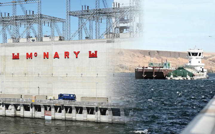
When the McNary navigation lock went into service in 1954, over 500,000 tons of cargo moved through it within its first year. Over the decades, the amount of river traffic has increased. In fiscal year 2021, more than 5.6 million tons of commodities, mostly grain and petroleum products, passed through the McNary navigation lock.
Today, McNary is an essential part of the river highway that was envisioned before the formation of the Walla Walla District. It sits as the midpoint, the last lock on the Columbia before the mouth of the Snake River.
With its 14 generator units, McNary is also an incredible source of hydropower, capable of producing 980-megawatts or enough electricity to power about 686,000 homes.
ONLY THE BEGINNING
In 2018, the Walla Walla District awarded a $321.3 million contract to Alstom Renewable US LLC, a General Electric company, to design, manufacture and install 14 new turbines at McNary Lock and Dam. This is part of a process to modernize hydropower all along the Columbia and Snake rivers by making turbines more efficient at generating electricity and safer for fish.
The plan is to design two types of new turbines for McNary: one with a fixed blade runner and one with an adjustable blade runner. The turbine blades are what the water pushes against, causing the turbine to spin and generate electricity.
It is estimated that replacing all 14 turbines at McNary will take 10 to 15 years. Meanwhile, McNary will continue to generate electricity and allow the passage of barges up and down the Columbia River.
Today, McNary is one of eight dams along the river highway between the mouth of the Columbia River and Lewiston, Idaho. When it was authorized in 1945, McNary Lock and Dam was just one of the first steps towards navigable waters.