


The National Oceanic and Atmospheric Administration (NOAA) has announced a major hydrographic survey of federal waters off American Samoa to map and characterize potential critical mineral deposits more than 30,000 square nautical miles in extent. The effort is part of the Department of Commerce’s implementation of the U.S. Offshore Critical Minerals Mapping Plan, a policy initiative aimed at cataloguing seabed resources seen as strategically important to U.S. manufacturing and defense supply chains, a NOAA press release said.
Work is scheduled to begin in February 2026, with NOAA contractor NV5, Hollywood, Fla., conducting the offshore surveys. NOAA will use approximately $20 million in fiscal year 2025 funding to produce detailed maps, imagery and environmental samples of the seafloor and water column. The resulting data will be made publicly accessible and is intended to support federal agencies, researchers and industry stakeholders in assessing the presence and relative prospectivity of critical minerals in the region.
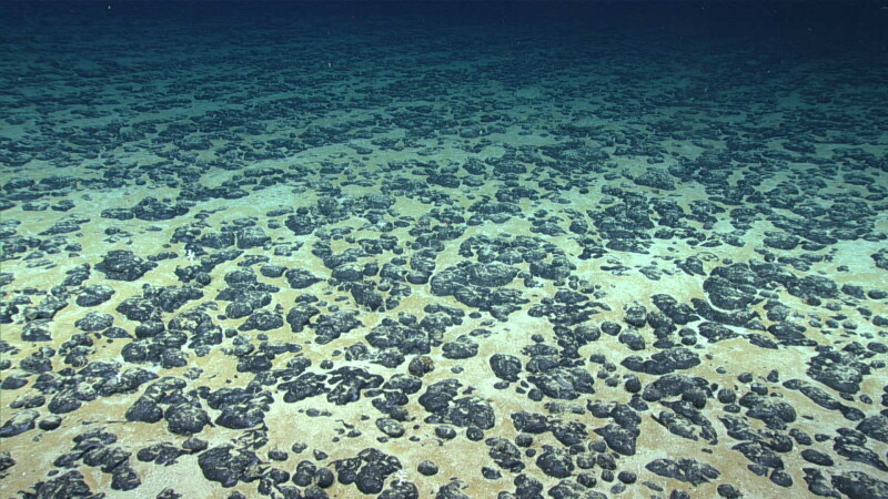
A key focus of the survey are Polymetallic nodules, which are rounded, mineral-rich deposits found on the deep ocean floor. These nodules can contain high concentrations of metals such as manganese, nickel, cobalt and copper, which are used in batteries, defense systems and a range of industrial applications.
“NOAA is proud to play a leading role in the President’s plan unlocking access to critical minerals for domestic supply chains,” said NOAA Administrator Neil Jacobs, Ph.D., in the agency’s announcement. According to NOAA, the project underscores the agency’s role in supporting economic resilience through research that could inform sustainable deep-sea mineral activities and improve understanding of marine environments.
The announcement comes just one day after NOAA revised the permitting process for deep seabed mining exploration and commercial recovery under the Deep Seabed Hard Mineral Resources Act (DSHMRA), establishing what the agency says is a consolidated application pathway intended to shorten timelines for prospective operators.
The American Samoa mapping initiative is tied to broader federal policy directives, including Executive Order 14285: Unleashing America’s Offshore Critical Minerals and Resources, which calls for expanded mapping and characterization of U.S. offshore mineral resources as part of efforts to reduce dependency on foreign suppliers.
NOAA expects the baseline data generated by the survey to stimulate further exploration, research and resource management projects, including those related to deep-sea minerals. While the mapping does not itself authorize mineral extraction, it provides foundational information that could shape future policy and permitting decisions.