


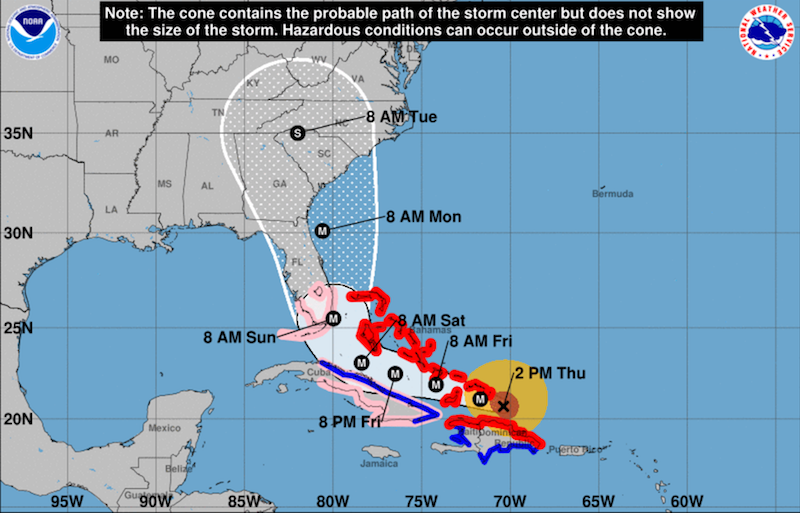
With category 5 maximum sustained winds of 175 mph as of 2 p.m. eastern, Hurricane Irma is moving between the north coast of Hispaniola and the Turks and Caicos Islands, on a potential track that threatens the Florida Keys and south Florida. Irma is moving west-northwest at 16 mph.
Just two weeks after Hurricane Harvey hammered the Texas energy coast, Irma’s threat to south Florida triggered accelerated preparations.
At 8 p.m. last night, the Coast Guard set Hurricane Condition X-RAY (sustained gale force winds from a hurricane force storm are predicted within 48 hours) in the Port of Key West, Fla.
All mariners are reminded that there are no safe havens in the Port of Key West area. For planning purposes, all oceangoing vessels and barges over 500 gross tons will be required to depart the Port of Key West and head out to sea if/when Hurricane Condition Yankee (24 hours before the on-set of gale force winds) is set. Inland vessels and barges over 500 gross tons are required to seek safe refuge in a port outside the Port of Key West area.
At 8 p.m. last night, the Coast Guard also set port condition Whiskey for the Port of Jacksonville and Fernandina and all other terminals and facilities due to the expectation of sustained gale force winds generated by Hurricane Irma that may arrive within 72 hours.
Effective at 12 p.m. today, the Coast Guard captain of the port (COTP) set port condition X-ray for the Port of Miami, Miami River, Port Everglades, Port of Palm Beach, Port of Fort Pierce and all other South Florida terminals and facilities due to expected sustained gale force winds of 25 mph and gusts up to 40 mph generated by Hurricane Irma that may arrive within 48 hours.
These ports and facilities are currently open to all commercial traffic and all transfer operations may continue while X-ray remains in effect.
Sustained winds between 39 and 54 mph are possible within 48 hours. Mariners are reminded that there are not safe havens in these facilities. All oceangoing commercial vessels and oceangoing barges greater than 500 gross tons should make plans for departing the port.
Vessels that want to remain in port must immediately contact the COTP to receive permission and are required to submit a safe mooring plan in writing. Vessels bound for South Florida that are unable to depart 24 hours prior to threatening winds making landfall are advised to seek an alternate destination.
Port facilities are advised to review their heavy weather plans and take all necessary precautions to adequately prepare for the expected conditions. Mariners can view the latest port updates on the Coast Guard’s Homeport site.
If and when port condition Yankee is set — sustained gale force winds are expected within 24 hours — vessel movement shall be restricted, and all movements must be approved by the captain of the port.
The Coast Guard is warning the public of these important safety messages: Stay off the water, secure belongings, stay clear of beaches, and stay informed. The public should monitor the progress and strength of the storm through local television, radio and Internet. Boaters can monitor its progress on VHF radio channel 16. Information can also be obtained on small craft advisories and warnings on VHF radio channel 16.
Also at 12 p.m., today, the COTP set port condition Whiskey for the Port of Charleston, S.C., and all other terminals and facilities due to the expectation of sustained gale force winds generated by Irma that may arrive within 72 hours.
These ports and facilities are currently open to all commercial traffic and all transfer operations may continue while Whiskey remains in effect.
At 10 a.m. today, the COTP set port condition X-ray for Port Canaveral terminals and facilities due to the expectation of sustained gale force winds generated by Hurricane Irma that may arrive within 48 hours.
Also at 10 a.m. today, the COTP set port condition Whiskey for the Georgia ports of Savannah and Brunswick and all other terminals and facilities due to the expectation of sustained gale force winds generated by Irma that may arrive within 72 hours.
With the five-day outlook from the National Hurricane Center showing potential paths over the Florida Keys, Monroe County officials ordered a mandatory evacuation of the islands’ 70,000 residents. Florida Gov. Rick Scott declared a state of emergency and activated the National Guard.

“The hurricane force winds in Irma are wider than Florida,” Bryan Norcross, a hurricane specialist at the Weather Channel, warned on Twitter. “You won’t need a direct hit to get Wilma-type winds & storm surge on both coasts.” Norcross is famed for his prescient warnings of Hurricane Andrew’s danger to south Florida in August 1992.