


Increased shipping traffic in the Arctic has led the United States and Russian Federation to jointly propose a new system of two-way routes for vessels to follow in the Bering Strait and Bering Sea, Coast Guard officials said Thursday.
The nations jointly developed and submitted the proposal to the International Maritime Organization (IMO) to establish six two-way routes and six precautionary areas. According to a November IMO document detailing the routes, published online by the Coast Guard, the project is in direct response to diminishing ice cover in the Arctic waters, and growing maritime interests in the region.
“During the summer of 2007 a record was set for a minimum sea-ice coverage in the Arctic which spawned increased interest in the Arctic and Sub-Arctic regions. Since then, international attention has been focusing on a changing Arctic climate and the potential for increased natural resource exploration as well as the possibility that shorter transit shipping routes could become more viable,” according to the U.S.-Russia submission to an IMO navigation subcommittee.
“The minimum summer sea-ice coverage record was broken again in 2012, furthering interest in natural resource exploration in the Arctic, as well as commercial and recreational use of the Bering Sea and Bering Strait as the main access route to or from Arctic waters,” the proposal stated. “This interest has manifested itself as increased cargo traffic, passenger ship traffic, adventure tourism traffic, oil and gas exploration, and research and scientific activities.
“This upward trend in ship traffic brings with it an increased likelihood of maritime casualties such as sinking, groundings, collisions, oil discharges and hazardous material releases, which in turn threatens the vulnerable marine environment, which is home to many endangered species and remote indigenous communities that rely heavily on traditional subsistence activities.”
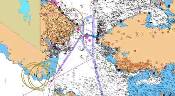
The proposed routes are in U.S. and Russian Federation territorial waters, off Alaska to the east and Russia’s Chukotskiy Peninsula to the west. The routes are drawn to help ships avoid the numerous shoals, reefs and islands outside the routes and to reduce the potential for marine casualties and environmental disasters.
The proposed two-way routes, planned with an eye to vessels of 400 tons or greater, would be voluntary for all domestic and international ships transiting the region. The Coast Guard says no additional Aids to Navigation (ATON) are being proposed to mark the recommended two-way routes, and the routing measures do not limit commercial fishing or subsistence activities. Commercial fishing accounts for about 52% of recorded vessel traffic in the region, the IMO paper notes.
“Over the past decade, the U.S. and Russia have both observed a steady increase in Arctic shipping activity,” said Mike Sollosi, the chief of the U.S. Coast Guard Navigation Standards Division.
Increased commercial and recreational traffic bring the increased risk of maritime casualties, said Sollosi, and the bilateral proposal for routing measures is designed to reduce that risk.
“The U.S. Coast Guard is engaging international and interagency partners across borders in developing joint proposals for ship routes in waterways that we share,” said Sollosi.
---
Stay updated on this story and more by subscribing to WorkBoat's free twice-weekly newsletters.