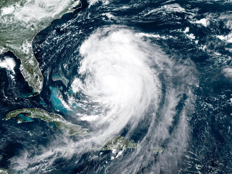
Hurricane Erin, the first major hurricane of the 2025 Atlantic season, has strengthened to a Category 4 storm with sustained winds of 130 mph. While not expected to make landfall, Erin poses significant threats to life, coastal infrastructure, and commercial maritime operations along the U.S. East Coast.
The National Hurricane Center said, “Erin is expected to produce life-threatening surf and rip currents along the beaches of the Bahamas, much of the east coast of the U.S., Bermuda, and Atlantic Canada during the next several days” (NHC advisory).
In North Carolina, officials ordered evacuations for Dare and Hyde counties, including Ocracoke and Hatteras islands, because of ocean overwash and potential road closures along N.C. Highway 12. The barrier islands face ongoing challenges from rising seas, erosion, and frequent storms, with millions spent annually on maintenance and post-storm repairs.
“Hurricane Erin will bring threats of coastal flooding, beach erosion, and dangerous surf conditions,” said Gov. Josh Stein. “North Carolinians along the coast should get prepared now, ensure their emergency kit is ready, and listen to local emergency guidelines and alerts in the event they need to evacuate” (governor.nc.gov)
.jpg.medium.800x800.jpg)
Commercial ports along the East Coast are experiencing impacts. The U.S. Coast Guard said it has set Port Condition YANKEE and Port Condition FOUR at select locations, signaling imminent gale-force winds and restricting vessel movements. Shipping routes, especially between the U.S. East Coast and Bermuda, face hazardous seas, creating navigation risks for commercial vessels. In North Carolina, concerns over NC Highway 12 further complicate freight and logistics for islands dependent on road and ferry access.
As Hurricane Erin moves northward, coastal communities and commercial maritime operators are urged to stay vigilant, monitor port advisories, and prepare for potential storm surge, rough seas, and shipping delays.
In its 11 a.m. Thursday update, the National Hurricane Center reported Erin’s center was located about 260 miles east of Cape Hatteras, with maximum sustained winds of 100 mph and minimal central pressure of 952 millibars and moving north-northeast at 18 mph.
“Erin is a very large hurricane,” NHC forecasters noted. “Hurricane-force winds extend outward up to 105 miles (165 km) from the center and tropical-storm-force winds extend outward up to 320 miles (520 km).”
Swimming was banned at many East Coast beaches because of dangerous surf. Continued evacuations were ordered in North Carolina’s Dare and Hyde counties and state highway officials closed Highway 12 from Oregon Inlet to Hatteras Village after overwash flooded the Outer Banks roadway.
As Erin slowly moved eastward, seas continued to build along the Mid-Atlantic shores into the New York Bight. Northeast winds of 25 to 30 knots with gusts up to 40 knots were forecast to increase to 30- 35 knots with gusts up to 45 knots Wednesday afternoon. Seas of 9’ to 13’ were building to 12’ to 16’.
“A faster northeastward to east-northeastward motion is expected during the next couple of days,” according to the NHC. “On the forecast track, the center of Erin will move over the western Atlantic between the U.S. East Coast and Bermuda through early Friday, and then pass south of Atlantic Canada Friday." and Saturday.”


