An experienced tow pilot was anticipating a strong cross current as he approached a Mississippi River bridge pushing 15 barges. But the current he had seen often before when transiting a bridge near Fort Madison, Iowa, did not appear, and the resulting tow contact led to $3.28 million in damage, according to a new National Transportation Safety Board report.
The 158’ Joe B. Wyatt was pushing 13 loaded hopper barges and 2 empty tank barges downriver on May 9, 2024, when the tow struck the bridge’s protection cell and fendering system and broke apart. No injuries or pollution were reported, but damage was done to the protection cell, fendering system, barges and the tow vessel.
The pilot had decades of experience maneuvering tows, including 15 trips through the Fort Madison Bridge’s primary channel.
“Based on this experience and his anticipation of a cross-current coming from around Dutchman Island, he maneuvered the tow over 200’ off the sailing line toward the right descending bank,” according to a summary written by NTSB investigators. “The cross-current, if present at the time, did not have the effect the pilot anticipated. Because the pilot overcompensated for the anticipated cross-current, the 1,153’ long tow was out of position as it approached the bridge.”
The pilot then increased engine power, trying to maneuver back toward the center of the channel. Despite his move to recover the third barge in the starboard string contacted the protection cell. The tow broke apart and 13 of 15 barges drifted downriver.
The Joe B. Wyatt had departed the Consolidated Grain & Barge Co., near mile 418 of the Upper Mississippi River around 4:45 a.m., pushing a tow of 15 barges downbound toward St. Louis, Missouri. The tow comprised three strings of five barges—two empty tank barges and 13 loaded hopper barges carrying various agricultural products, including corn, soybeans, and grain. There were eight crewmembers aboard, including a captain and a pilot.
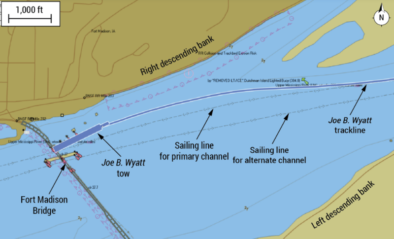
At 1:06 p.m. with the pilot at the helm, the Joe B. Wyatt tow passed the southwest end of Dutchman Island, about a mile upriver from the Fort Madison Bridge, at 8.2 mph. The tow was about 65 feet right (toward the right descending bank) of the charted primary sailing line. Between Dutchman Island and the right descending bank, a small portion of the river separated from the main body and reconnected after about a mile; this configuration could create a cross-current for vessels attempting to navigate through the Fort Madison Bridge.
Anticipating that a current coming around Dutchman Island would set the tow toward the left descending bank, the pilot intentionally steered the tow to the right of the primary channel sailing line. The Joe B. Wyatt was as much as 226’ to the right of the sailing line as the pilot made his approach to the bridge’s primary channel. While the pilot navigated the tow toward the bridge, two deckhands were positioned at the head of the tow on the port and starboard sides, relaying distances to the channel opening to the pilot.
About 1:08 p.m., as the pilot later told NTSB investigators, he realized the anticipated cross-current “wasn’t holding [him] up” as he had expected and the tow was in danger of striking a bridge protection cell on the right descending bank side.
With the tow traveling about 8 mph and the lead barge about 1,900’ away from the bridge, the pilot increased the engine rpm (power) to attempt to maneuver the tow back toward the center of the channel. About 1:11 p.m., the head of the Joe B. Wyatt tow was passing the eastern (upriver) end of the bridge’s central fendering system, the Joe B. Wyatt was still right of the sailing line by about 210’, traveling 9.8 mph, and the pilot was attempting again to regain position toward the center of the channel.
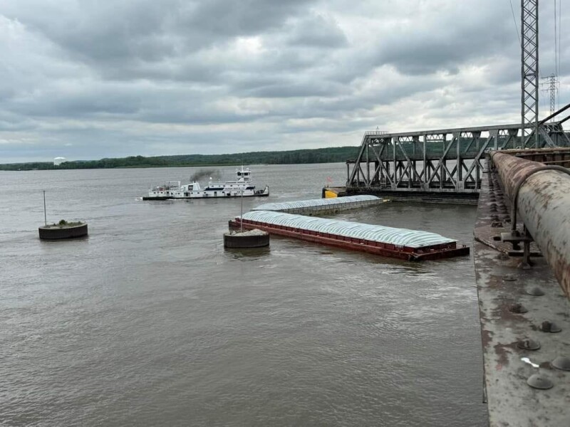
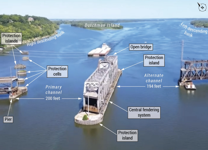
About 1:12 p.m., as the forward portion of the tow continued into the Fort Madison Bridge’s primary navigational channel, the third barge (IN115504) in the starboard string contacted a protection cell located at the base of a bridge pylon and began to slide along its side. The front three rows shifted several feet to port. As the third barge from the head of the tow in the starboard string continued to slide along the cell, the corner of the fourth barge (IN122011) from the head of the tow in the starboard string dug into the side of the cell and abruptly stopped the forward momentum of the Joe B. Wyatt.
The pilot sounded the general alarm, and the captain came to the wheelhouse. The force of the Joe B. Wyatt stopping broke apart the tow, sending 13 of 15 barges through the span and downriver, with both deckhands still aboard. Two barges (IN122011 and IN155499) became lodged between the protection cell and the tug and remained upstream of the span. River currents caused barges IN122011 and IN155499 to drift across the channel.
The pilot noticed the aftmost barge (IN155499) taking on water and blocking the channel as it rested alongside the bridge’s central fendering system He pushed the sinking barge along the central fendering system through the span and grounded it on the right descending bank, about 1,920’ downstream of the bridge.
The National Transportation Safety Board determined that the probable cause of the contact of the Joe B. Wyatt tow was the pilot overcompensating for anticipated river crosscurrents during the tow’s approach to a bridge.
“Generally, a sailing line is assigned to a known safe route used by commercial vessels,” NTSB investigators wrote in a “lessons learned” postscript to their report. “A sailing line is developed with consideration of channel depth, current patterns, and any other known obstructions to navigation. A charted sailing line provides for a safe and successful transit when used as a guide, along with the mariner’s own experience and assessment of the existing circumstances.”