


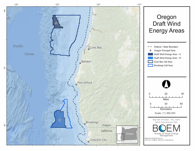
Two proposed wind energy areas located 18 to 32 miles off the southern Oregon coast would total less than 220,000 acres – much less than potential development areas first outlined by the federal Bureau of Ocean Energy Management in April 2022.
The Aug. 15 announcement from BOEM starts a 60-day public comment on the proposal. This new draft document comes after calls from Oregon state officials and the North Pacific Fishery Management Council for BOEM to rethink its analysis of wind energy development and potential conflicts with fishing, maritime shipping and environmental issues.
As now proposed the areas would total 219,568 acres of federal waters – a reduction of 81 percent from BOEM’s original “call areas” drawn in 2022 to gauge wind developers’ interest and stakeholders’ reactions.
The agency will “continue to prioritize a robust and transparent process, including ongoing engagement with Tribal governments, agency partners, the fishing community, and other ocean users,” said BOEM Director Elizabeth Klein in announcing the proposal.
“At the request of Oregon’s governor and other state officials, there will be a 60-day public comment period on the draft WEAs and BOEM will hold an intergovernmental task force meeting in addition to public meetings during the comment period,” said Klein. “We look forward to working with the state to help us finalize offshore areas that have strong resource potential and the fewest environmental and user conflicts.”
BOEM worked with the National Oceanic and Atmospheric Administration’s National Centers for Coastal Ocean Science (NCCOS) to use an ocean planning model “that seeks to identify and minimize conflicts,” according to BOEM.
The NCCOS report issued in August analyzed those issues, using a complex “suitability model” that collected data from a year-long effort gathering information from stakeholders. The researchers sorted the data into 30 “geospatial data layers” to compare the attributes and drawbacks for using areas of the ocean that BOEM had split into the Coos Bay Call Area of 872,854 acres and the Brookings Call Area at 286,444 acres.
The NCCOS analysis pushed much of those call areas out of bounds, over Department of Defense concerns over how future wind turbine construction could affect the military’s use of the ocean and airspace offshore. The Coast Guard’s ongoing studies of West Coast shipping routes and wind power development was a factor too, leading researchers to recommend shifting the areas west away from fairways between Oregon ports.
Other spatial layers entered into analysis include commercial and recreational fisheries, wildlife habitat, birds, endangered and protected species, and existing seafloor cable installations.
BOEM’s resulting choices are a 61,204-acre site about 40.6 miles northwest of the Coos Bay, and a 158,364 acres site 23.5 miles west of Brookings Harbor.
Unlike wind projects under construction on the shallow continental shelf off the U.S. East Coast, future West Coast projects would require mooring turbines on floating platforms. The Brookings Harbor offshore area for example has depths ranging from 1,860 feet down to nearly 5,000 feet, with a mean water depth of 3,044 feet.
In June Oregon Gov. Tina Kotek and members of the state Congressional delegation called on the federal Bureau of Ocean Energy Management to slow down its planning process for offshore wind energy projects and better evaluate their impact on the environment and Oregon’s economy.
“Many valid questions and concerns remain about floating offshore wind,” Kotek wrote in a June 9 letter to BOEM director Elizabeth Klein. “These must be addressed transparently before we can support proceeding further toward any substantial development decisions on the Oregon coast.”
The letter was also signed by Sens. Ron Wyden and Jeff Merkley, and Reps. Val Hoyle and Suzanne Bonamici, all Democrats. Their concern was a subtle but significant shift from generally strong support for the Biden administration’s wind energy priorities among Democratic leaders in coastal states.
The Affiliated Tribes of Northwest Indians asked BOEM for a halt in the process. At its March meeting in Seattle, the Pacific Fishery Management Council called on the agency to completely set aside the planning process and start anew, using more planning tools “to minimize siting impacts to fisheries and ecosystem resources.”
The council said BOEM should rescind its previous mapping of the Brookings and Coos Bay call areas, and “restart the process to identify call areas and consider all water off Oregon from 12 miles and beyond, including waters that are greater than 1,300 meters in water depth, and using marine spatial planning tools to minimize siting impacts to fisheries and ecosystem resources.”
The BOEM announcement starts the clock on a new 60-day public comment period until midnight Oct. 16. In an Aug. 8 letter to BOEM director Klein, the Oregon congressional delegation acknowledged the agency was moving to releasing the WEA map, but urged caution.
"While your response letter in July of 2023 explained a number of efforts BOEM is working on to engage and inform the public, we remain concerned the process is not adequately engaging all voices in the planning process," the lawmakers wrote. "It is critical that BOEM develops a deep appreciation of all community interests and fully studies every opportunity to reduce conflict with all ocean users before making substantial development decisions."
“Public input from this new comment period will be considered before formally designating final WEAs off the coast of Oregon,” according to the agency. “BOEM will hold public meetings to outline data and information used to inform the draft WEAs and to discuss next steps. The meetings will be open to the public, with one specifically designed for engaging the fishing community.”
Information on the webinars will be available on the BOEM Oregon state activities page.
To comment on the draft WEAs, go to the federal website regulations.gov and search for docket number BOEM-2023-0033.
Offshore wind advocates at the Business Network for Offshore Wind said the BOEM siting proposal, while reduced in area, keeps those areas viable for future development.
“Critically, BOEM maintained the vast majority of the WEAs in water depths less than 1,300 meters deep,” the group said in a statement Tuesday. “While this depth will require advanced floating technology, it remains within the capability of near-term technological development. With the release of draft WEAs, BOEM is maintaining the leasing schedule it committed to in 2021.”