


As offshore energy infrastructure expands and ages, operators are under increasing pressure to monitor pipelines, cables, and seabed assets more efficiently. Advances in subsea robotics, autonomous vehicles, and digital data platforms are beginning to reshape how offshore inspection, maintenance, and survey work is conducted.
Across the oil and gas sector in the Gulf and emerging offshore wind regions, companies are investing in systems that reduce vessel days, limit personnel offshore, and accelerate the flow of subsea data from the seabed to decision-makers.
For Houston-based Oceaneering International, that transformation is centered on three technological themes.
“When we’re talking about subsea, there are three key themes we are working on, which we see will become very prominent in the next 10 years,” said Nikunj Patel, Oceaneering’s vice president of engineering and operations. “They are already very important… and those are what we call remote operations, autonomy, and residency.”
Together, those trends point toward a future where subsea robotic systems operate longer, gather more data, and increasingly work with fewer personnel offshore.
REMOTE OPERATIONS
One of the most immediate changes in subsea operations is the rise of remote piloting for underwater vehicles. Traditional remotely operated vehicle (ROV) operations require pilots and technicians stationed onboard offshore support vessels. Today, thanks to improved satellite communications and subsea connectivity, many of those roles can be transitioned to shore.
“So when we’re talking about remote offshore operations, a simple example in Norway, almost 60% of the piloting work we do, we do from onshore,” Patel said.
In these scenarios, ROVs operate thousands of feet below the surface while pilots control them from offices miles away.
According to Patel, remote ROV operations unlock several key advantages. “Cost is definitely an advantage for the customer. But the critical one is from the carbon footprint point of view… and safety,” he said, noting that offshore personnel reductions also lower exposure to harsh offshore environments while minimizing travel and vessel mobilization costs.
Connectivity has historically limited remote operations in some regions, but that barrier is gradually disappearing.
“Norway is very mature. The reason is the connectivity offshore is really good,” Patel said. “Some of the regions, they are spotty because the satellite communication is the weak link. But that’s changing also with Starlink and some of the other technology availability.”
AUTONOMOUS INSPECTIONS
The second major shift is autonomy. While most offshore tasks still involve a human operator, certain repeatable inspection tasks can now be performed autonomously.
“I think we are still quite [a ways] away from full autonomy,” Patel said. “But simple operations like pipeline inspection, that’s very much fully automated right now.”
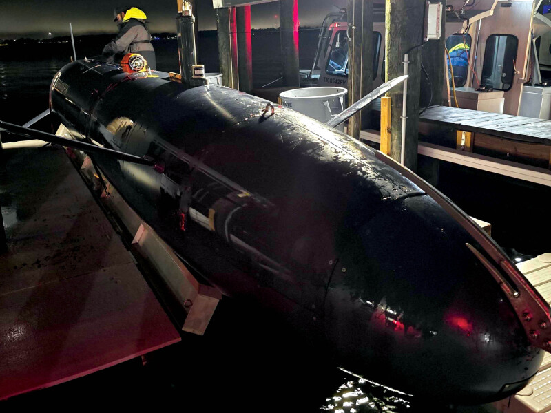
Oceaneering has spent nearly a decade developing a tetherless autonomous underwater vehicle (AUV) that can be programmed to inspect long pipeline corridors without direct human control.
“We have a platform called Freedom, where you can just launch that. ‘Okay, go to this location, follow this 16-inch pipe, go 60 miles, capture all the data, and come back,’” Patel said. “Very much we can do it right now.”
Automation is also being integrated into traditional work-class ROVs through pilot-assist functions designed to handle repetitive tasks.
“It’s similar to driving a Tesla or any modern car,” Patel said. “Still, a human has to drive, but you can just follow the lane.”
SUBSEA RESIDENCY
Another emerging development is subsea residency, which entails designing robotic systems capable of remaining underwater for extended periods. Historically, ROV and AUV operations have followed a cycle of deployment, recovery, and maintenance.
“We used to call retrieve and repair,” Patel said. “Use for eight hours, recover, repair, deploy again.”
New and future systems are being designed to remain subsea for months or even years, Patel said. “We already have capabilities where we can charge them subsea,” he explained. “We already have capabilities where we can communicate with them subsea.”
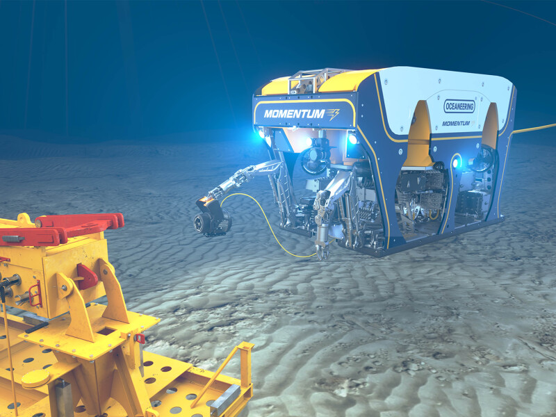
Oceaneering’s recently introduced Momentum electric work-class ROV reflects that shift toward longer subsea endurance. “We can work subsea for 30 days without retrieving,” Patel said. “Where traditional hydraulic ROV, you have to retrieve every other day to do routine maintenance.”
PARALLEL SUBSEA OPS
Autonomous vehicles are also enabling new operational models offshore. Instead of dedicating an entire vessel to a single installation or inspection task, operators can run multiple subsea operations simultaneously.
“Normally nowadays you have a vessel… doing some repair work or doing some installation work,” Patel said. “Right now, that whole vessel is just focused on doing one installation.”
With autonomous systems operating alongside those vessels, additional inspection work can take place at the same time. “We do a scenario where the same vessel is also launching the Freedom,” he said. “When the vessel is involved doing the installation work, Freedom is doing all the other pipeline inspection… simultaneously.”
Oceaneering has already begun deploying this approach in offshore projects in West Africa, where autonomous vehicles conduct pipeline inspections while installation vessels complete other tasks nearby.
“I think what we see is parallel operations with the same assets will become very prominent,” Patel said.
Data to Intelligence
Wider use of digitally connected subsea robots is generating larger volumes of inspection data, creating a new challenge: how to use that data most effectively. Patel said the technical capabilities now exist to collect, process, and analyze massive datasets, but industry practices have not fully evolved to support those capabilities.
“The biggest gap in industry right now is not technology,” he said. “It’s a terms and condition between customers and vendors. And what that means is legacy oil and gas terms and conditions are not changed with the change in technology.”
Oceaneering has “terabytes and terabytes of data,” Patel said. “We have it. We store for the customer. We cannot use it.”
Because the data collected during offshore inspections typically belongs to the operator, contractors often cannot use those datasets to train analytics models or improve digital tools.
Even many operator engineers recognize the inefficiency. Patel noted that discussions are ongoing across the offshore energy sector about how contractors might responsibly use operational datasets while protecting customer intellectual property.
“There’s an active topic in this industry right now… what is the best way to write those terms and conditions?” Patel said. “And it’s not an Oceaneering struggle… This is the true industry-wide problem.”
ASSET MAPPING
One way the industry is beginning to extract more value from inspection data is through digital visualization and asset modeling. Rather than focusing solely on individual inspection reports, companies are increasingly building detailed three-dimensional models of subsea infrastructure.
“Normally, we don’t use the [phrase] ‘digital twin,’ because it means a lot of different things for different people,” Patel said. “But in short… we can map everything in a 3D environment, and we can do inspection based on those mappings.”
Oceaneering’s integrity management and digital solutions group is working with customers to develop these capabilities through its collaboration with Aberdeen, Scotland-based Global Design Innovation (GDi).
The agreement allows Oceaneering to provide customers with digital solutions that support remote inspection, digital asset management, and operational support services designed to improve safety, data quality, and cost efficiency.
The partnership builds on GDi’s Vision 3D visualization software, which Oceaneering has expanded with a subsea inspection module called Vision Subsea. It presents engineering-grade point-cloud data generated during ROV operations, giving engineers a measurable, contextual view of subsea asset integrity.
The system allows engineers to identify anomalies, perform dimensional checks, and plan interventions using spatially accurate inspection data rather than relying on fragmented drawings or video footage lacking scale.
Delivered as a cloud application, the platform allows integrity, inspection, and planning teams to collaborate remotely while reducing the need for repeat vessel mobilizations. The visualization tools also allow operators to monitor structural changes over time.
“So, let’s say you have a jumper [transporting oil, gas, or injection fluids between two subsea components], and the seabed changes over the year,” Patel said. “If we have a 3D model of that jumper… we can see how that jumper behaves over the life of the 10 years.”
With that information, engineers can evaluate whether structural components are experiencing loads beyond their original design parameters. “We can calculate back on [whether] the jumper is seeing any additional loads [beyond] what it was designed to,” Patel said.
Autonomous inspection systems such as the Freedom AUV help enable that approach by collecting large volumes of spatial data — point clouds — more efficiently. “Capturing those images and 3D point cloud becomes very cost-effective,” Patel said. “You don’t have to send the vessel every time to do so, which [saves] hundreds and thousands of dollars a day.”
OCEAN OPERATING SYSTEM
Terradepth is another company that has set out to help tackle subsea data management challenges. The Austin, Texas-based company is developing software infrastructure designed to centralize and organize survey and inspection data inside energy companies.
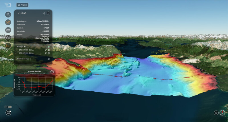
The company is positioning its Absolute Ocean (AO) software not as a standalone data portal, but as the core system of record powering what company officials describe as an “ocean operating system,” which connects data collection, data infrastructure, and operational applications into a unified environment for offshore operators.
“We’re not just a place to access data,” said Brian Butler, vice president of offshore energy at Terradepth. “We’re a lifecycle workflow solution. We’re compressing the time between collecting data and making a decision.”
The AO platform ingests bathymetric and subsea datasets from multiple sources, including Terradepth’s own long-range diesel-electric AUV, third-party contractors, operator-owned vehicles, and public datasets such as NOAA surveys, and centralizes them into a single enterprise system.
For offshore oil and gas operations, where subsea infrastructure is both mission-critical and proprietary, that enterprise positioning is key.
Rather than serving as a public-access data marketplace, AO is structured to warehouse operator-owned survey data, automate processing, enable visualization, and facilitate secure collaboration across departments.
The goal is to collapse what has historically been a fragmented workflow. In years past, survey data was often stored on external drives, processed in isolated systems, and shared through static reports or PDFs. In some cases, organizations have repeated surveys simply because prior datasets could not be located or accessed efficiently.
“One of our clients told us they would re-contract a survey because they couldn’t find the previous one,” Butler said. “That’s the level of inefficiency we’re helping eliminate.”
In offshore energy, time at sea directly correlates to cost. Large survey vessels with professional crews, multiweek mobilizations, and delayed onshore data processing can drive project expenses quickly into six figures per day.
Terradepth’s model aims to reduce that burden. Its long-range AUVs can be port-launched or supported by a smaller support vessel, depending on mission scope. That reduces vessel size requirements, crew count, and overall days at sea. Surveys that might traditionally require three weeks can, in some cases, be completed in roughly one, Butler noted.
The company’s flagship vehicle is designed around a modular, open-architecture payload system capable of supporting multiple survey-grade sensor packages. These can include side-scan sonar, multibeam systems, sub-bottom profilers, magnetometers, and environmental monitoring packages. Payload configurations can be tailored to project requirements, allowing operators to optimize for resolution, depth, endurance, and data objectives without changing the underlying vehicle platform, a company spokesperson said.
Because the vehicle uses a diesel-electric hybrid architecture rather than relying solely on battery power, Terradepth said it can manage onboard power budgets more flexibly while delivering longer range and endurance at a lower operating cost compared with battery-only systems. The approach allows operators to extend mission duration and sensor usage while maintaining survey-grade performance.
The time savings extend beyond data collection. Automated processing built into the AO workflow allows data to be processed while the vehicle remains in the field, rather than waiting until the mission concludes. Engineers and hydrographers can review results remotely from shore, collaborating in near real time without deploying additional personnel offshore.
The operational impact of that approach was tested recently when a major offshore oil and gas operator reported a potential pipeline anomaly. Time was the primary constraint.
Instead of launching a prolonged conventional survey campaign, Terradepth deployed a rapid-response team supported by an autonomous surface vessel to execute a targeted multibeam water-column survey directly over the pipeline corridor. Rather than surveying broad swaths of seabed, the team concentrated data acquisition in the area of interest.
Survey results were delivered through AO, allowing facilities and integrity managers to review investigation-grade data almost immediately instead of waiting through conventional reporting cycles. According to Terradepth, compressing the collection-to-delivery timeline from weeks to days saved roughly $100,000 per day in vessel and logistics costs while providing decision-ready insight to stakeholders.
SUBSEA INTELLIGENCE
As offshore infrastructure grows more complex, operators are increasingly shifting away from episodic surveys toward continuous monitoring of subsea assets.
Autonomous robotics, long-duration subsea vehicles, and centralized data platforms are enabling a more persistent view of the ocean floor.
Digital systems allow engineers to track seabed changes over time, monitoring pipeline exposure, sediment migration, or cable movement without repeating entire survey campaigns.
For companies managing global portfolios of offshore infrastructure, the operational impact can be substantial.
“The more people using the platform, the more operational efficiencies you gain,” Butler said. “It makes the day-to-day life easier for users, but it also impacts the bottom line.”
Combined with advances in robotics and digital asset management, subsea inspection is moving toward a future where offshore infrastructure can be monitored continuously and managed increasingly from shore.
“The future will be different,” Patel said.