


A new artificial intelligence-driven method for measuring ocean surface currents could improve how operators, researchers, and agencies understand rapidly changing ocean conditions, with potential applications ranging from search and rescue to spill response.
Detailed in a study published in Nature Geoscience, the approach—called GOFLOW (Geostationary Ocean Flow)—uses AI to analyze thermal imagery from existing weather satellites to map ocean currents at finer spatial and temporal scales than previously possible. The work includes contributions from Nick Pizzo of the University of Rhode Island Graduate School of Oceanography.
Unlike traditional observation methods that rely on infrequent satellite passes or limited-area ship and radar measurements, GOFLOW leverages continuous data streams from geostationary satellites already in orbit. Researchers said the method requires no new hardware, allowing it to build on existing infrastructure.
Ocean currents play a central role in global weather patterns, climate regulation, and marine ecosystems, moving heat, carbon, and nutrients throughout the ocean. But capturing the smaller-scale features that drive vertical mixing—where surface and deeper waters exchange properties—has remained a challenge.
“In areas where the ocean pushes together and pulls apart, information from the atmosphere and ocean interior are exchanged in ways we do not fully understand,” said Pizzo. “This is one of the most exciting areas of physical oceanography today.”
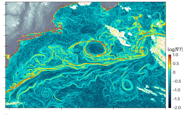
Those processes can occur over distances of less than 10 kilometers (6.2 miles) and evolve within hours, making them difficult to observe with conventional tools. Existing satellite systems may only revisit the same area every 10 days, missing short-lived but impactful events.
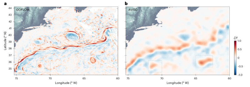
The GOFLOW system addresses that gap using a deep learning model trained on high-resolution ocean circulation simulations. The model identifies how surface temperature patterns shift as underlying water moves, then applies that understanding to real-world satellite imagery. Initial testing using data from the GOES-East satellite in the North Atlantic showed strong agreement with shipboard measurements in the Gulf Stream, while also resolving smaller, more energetic features tied to vertical mixing.
For maritime operations, improved visibility into these dynamics could support more accurate drift modeling for search-and-rescue missions, better tracking of oil spills and marine debris, and enhanced route planning in dynamic current systems.
“We are using this real-world inference to better understand how the ocean transports important quantities like heat from one place to another, and how vertical motions that are important for exchanges between the atmosphere and the ocean are supported,” Pizzo said.
The research was co-led by Luc Lenain of Scripps Institution of Oceanography at the University of California San Diego and Kaushik Srinivasan of the University of California, Los Angeles, with contributions from Roy Barkan of Tel Aviv University. The project received support from the Office of Naval Research, NASA, and the European Research Council.
Researchers said the next steps include expanding GOFLOW to global coverage and improving performance in areas with persistent cloud cover. Longer term, the method could be integrated into operational forecasting systems, providing higher-resolution inputs for weather prediction, climate modeling, and ocean monitoring.