A quartet of uncrewed surface vehicles are navigating 1,500 miles to the center of a historic El Niño gathering strength in the eastern Pacific, on a four-month mission to collect data on the warm-water impulse altering global weather patterns.
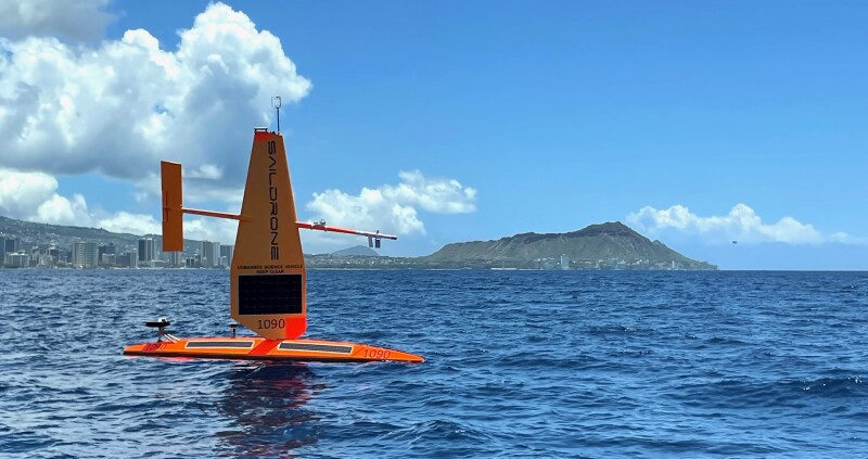
Two orange Saildrone Explorer 23' USVs sailed Aug. 21 from Honolulu, carrying meteorological and oceanographic sensors and rendezvousing with two other Saildrones on a 6,000-mile round-trip mission for NOAA’s Pacific Marine Environmental Laboratory (PMEL) according to a summary from the agency.
“A monumental El Niño is knocking at the door,” said Michael McPhaden, former PMEL senior scientist now working with NOAA’s Cooperative Institute for Climate, Ocean, and Ecosystem Studies (CICOES). “We’re going to take a closer look.”
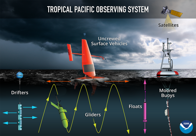
The USVs will steer courses through the Tropical Pacific Observing System, a multi-national array of data-collecting moored surface buoys that provide continuous, real-time hourly tracking of surface winds, air temperature, humidity, and upper-ocean temperature down to 1,640’. Argo floats collect ocean profiles down to 1.24 miles every 10 days.
Distributed throughout the array are drifting buoys measuring sea surface temperature and currents. Overhead, satellites track the drifters and capture surface observations across wide areas.
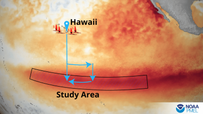
“The Saildrones will gather data at one-minute intervals several hundred yards apart, gaining additional information between existing ocean sensors,” according to the mission summary. “The data they collect allows scientists to map out the boundaries or fronts between the warm tropical water and normally cool water to the east, on the equator, as well as compare observations captured by satellites, moorings, floats, and other autonomous platforms to ensure consistency.”
“Satellites are great for giving you wide-area coverage,” said research oceanographer Meghan Cronin, a PMEL lead on the Saildrone mission.
“But you still want to put a thermometer in the water to make sure you’re getting an accurate measurement. Saildrones carry a whole suite of additional sensors that allow us to measure the exchange of heat from the ocean surface to the atmosphere, and the changes from CO2 outgassing from the ocean to the ocean’s uptake of CO2, as we cross the ocean fronts near the equator.”
Before the advent on USVs getting that thermometer and suite of sensors to the middle of the ocean required months of planning, the availability of large, specialized research vessels, and teams of scientists spending months at sea.
Since 2001, NOAA has dramatically stepped up its use of uncrewed systems for ocean research – both reducing risks to human safety and collecting accurate data at a fraction of the cost of traditional research cruises.
During an Eastern Pacific El Niño, like the one currently underway, warming is strongest in the eastern equatorial Pacific and off the coast of South America. This fundamental relocation of heat and storms alters the jet stream which triggers downstream weather disruptions across the globe – such as severe droughts in Australia and heavy rainfall or flooding in the southern United States.
In addition to standard measurements, the Saildrones will capture observations of various small-scale processes (like equatorial upwelling and intense air-sea interactions associated with fronts) that cannot be well resolved by the mooring array, gliders, or satellites. These processes often lead to the explosive development of massive thunderstorm systems and individual storms that can influence the migration of warm water and the development of El Niño.
Funded by NOAA’s Uncrewed Systems Operations Center, the team is composed of researchers from PMEL and its University of Washington cooperative institute, CICOES, as well as scientists with NOAA’s National Marine Fisheries Service and the National Weather Service’s Climate Prediction Center and National Data Buoy Center.
“Remotely piloted, long-range uncrewed surface vehicles open a new era of ocean observation by targeting areas where data are most needed to improve our understanding and forecasts of high-impact, rapidly developing air-sea processes like this El Niño, that will have profound effects around the world,” said Dongxiao Zhang, lead scientist of this project at CICOES.