


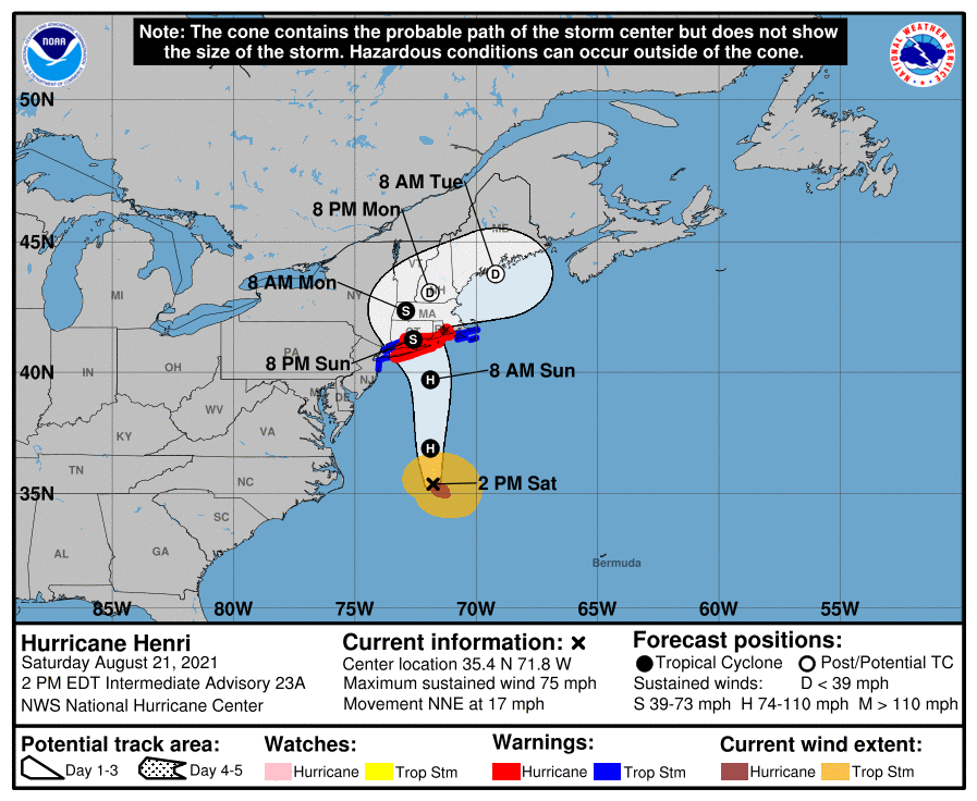
Gaining strength, hurricane Henri steamed north off the Carolina capes Saturday as storm surge warnings were raised from Long Island to Cape Cod.
The National Hurricane Center projected a Sunday afternoon or evening landfall on Long Island, with Montauk, eastern Connecticut and Rhode Island in the powerful northeast quadrant of the storm.
NHC modeling suggested a storm center track over central Connecticut, before a sharp right turn over New England to re-emerge as a tropical depression over the Gulf of Maine Tuesday.
Tropical storm warnings spanned the region from New York Harbor to Provincetown, Mass. Connecticut Gov. Ned Lamont declared a state of emergency, while Massachusetts Gov. Charlie Baker activated around 1,000 National Guard members to prepare for rescues using high-water vehicles and to clear debris from roads.
At 11 a.m. Saturday the hurricane center said Henri had achieved 75 mph sustained winds, moving up as a category 1 storm. A north-northeast course at 17 mph forward speed was expected to shift north-northwest Saturday evening.
At around 11:45 a.m. Saturday the Coast Guard set port condition Yankee for New York, New Jersey and Long Island Sound, limiting vessel movements in anticipation of gale-force winds within 24 hours.
On Long Island Sound, all vessels over 300 gross tons and all tank barges and their supporting tugs must submit a transit plan and receive approval from the Coast Guard Sector Long Island captain of the port prior to movement.
“Oceangoing vessels over 300 gross tons and all oceangoing barges and their supporting tugs opting to remain in port during the storm, must complete a remaining in port checklist and submit it to the captain of the port immediately for approval,” according to a Coast Guard statement.
“All self-propelled oceangoing vessels over 300 gross tons and all oceangoing barges and their supporting tugs, if opting to remain in port during the storm, must comply with COTP Long Island Sound mooring requirements.”
Tides already running higher with the August full moon can boost predicted storm surges of 3 to 5 feet from Flushing, N.Y., to Chatham, Mass., and Narragansett Bay, Buzzards Bay, Vineyard Sound, and Nantucket Sound. Similar heights were expected on north shore of Long Island, from Flushing to Montauk Point, and on the south shore from Mastic Beach to Montauk Point.
With hurricane force winds at landfall widespread power outages are anticipated on Long Island and in most of Connecticut and Rhode Island. Henri could have widespread effects not seen in the region since hurricanes Gloria in 1985 and Bob in 1991, but it’s not expected to be close to the aftermath of Sandy in 2012 around the New York City and New Jersey coasts.