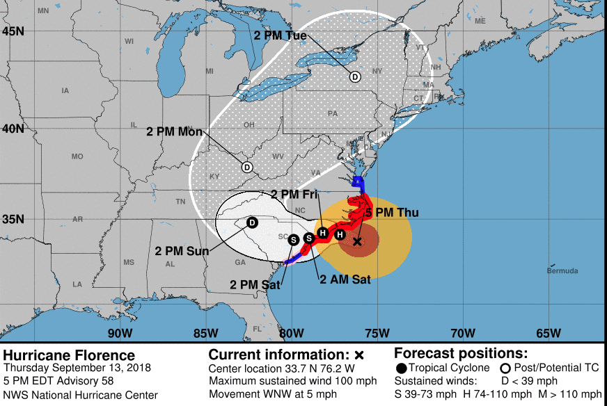
Final preparations went into place Thursday as a slowing Hurricane Florence gave the coastal Carolinas a little more time to prepare for the storm's devastating power.
Port preparations extended from Savannah, Ga., north to Baltimore, as forecasters at the National Hurricane Center issued increasingly narrowed predictions for the passage of Hurricane Florence. After a Friday landfall near Cape Fear, N.C., the storm is expected to drift slowly west, battering the Carolinas through the weekend.
A hurricane warning was in effect from the South Santee River in South Carolina to Duck, N.C., almost 400 miles. At 1 p.m. Thursday the storm was churning maximum sustained winds of 105 mph located about 115 miles south-southeast of Wilmington, N.C., according to the hurricane center. The center reported a satellite altimeter measured wave heights as high as 83’ in the northeast quadrant of the storm.

The storm could strengthen as it continues to move over the warmest sea surface temperatures around 84 degrees Fahrenheit with little wind shear Thursday. Some weakening could occur as Florence moves across cooler waters and draws upwelling on the shallow continental shelf, but that will not lessen the storm’s danger, NHC forecasters said.
On Thursday the storm lost some wind speed and slowed its forward motion to around 9 knots as it approached the coast for a landfall Friday. But that will not lessen the threat from storm surge pushed by the storm, which could reach many miles inland up North Carolina's Neuse and Pamlico rivers, forecasters warned.
Coast Guard shallow water rescue teams took up positions in preparation for search and rescue operations once the worst of the storm passes.
"We have crews sheltered in place at this time, waiting for the storm's passage," said Capt. Bion Stewart, the Coast Guard incident commander for Hurricane Florence. Coast Guard officials urged peopkle needing help to call 911 -- and not to use social media, such as Facebook, to seek help.
Other small boat teams were arriving in the region, including volunteers of the Cajun Navy, a network of groups from Louisiana, and Task Force 1, an urban search and rescue team based in New Jersey.

Petty Officer 1st Class Mike McHuge from the Coast Guard Gulf Strike Team checks the outboard engine of one of the Shallow Water Urban Search and Rescue boats staged in Augusta, Georgia, Sept. 13, 2018 in preparation for Hurricane Florence. Coast Guard photo/PO 1 Bret Tindal.
Weak steering current will allow the hurricane to drift westward along the South Carolina coast and inland, and center over the state’s interior Sunday morning, the NHC projected. By Monday the storm, eroding toward becoming an extratropical low, will move north across western North Carolina and eastern Tennessee as it moves up the Appalachian Mountains -- potentially dumping even more rain in the Ohio River watershed, where rivers are already high from moisture carried north by the remains of tropical storm Gordon.
The likelihood that Florence will pound the coast for days not hours underscored flooding risks from both storm surge and rainfall measured in feet. Surges could reach 9’ to 13’ on the southeast North Carolina coast between Cape Fear and Cape Lookout, including the Pamlico and Albemarle sounds and their rivers, and 6’ to 9’ on the adjacent stretches of coast.


