


NOAA’s Office of Ocean Exploration Office of Ocean Exploration and Research and the ocean data and technology company Ocean Infinity have announced a new agreement to develop deepwater autonomous technologies that can gather ultra-high-resolution ocean information.
The four-year Cooperative Research and Development Agreement (CRADA) between NOAA and Ocean Infinity will also focus on advancing telepresence or the transmission of ocean information in real time to public and academic audiences as well as new data-collection and processing methods to increase the value and relevance of deep-ocean data.
“This new partnership will help us more efficiently execute NOAA’s mission to advance unmanned drone systems and artificial intelligence to explore and map the United States Exclusive Economic Zone,” said Neil Jacobs, Ph.D., acting NOAA administrator. “Data and information about the ocean help our nation advance our Blue Economy, including maritime commerce, domestic seafood production, healthy and sustainable fisheries, coastal resilience, energy production, tourism and recreation, environmental protection and national security.”
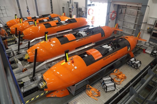
Each of Ocean Infinity’s multi-purpose vessels are equipped with hangars on the back-deck that house up to eight of state-of-the-art autonomous underwater vehicles.
The collaboration will support the recent Presidential Memorandum on Ocean Mapping in the U.S. Exclusive Economic Zone and Shoreline and Near Shore of Alaska and the goals announced at the November 2019 White House Summit on Partnerships in Ocean Science and Technology.
“This is an exciting step for Ocean Infinity as we combine our leading deepwater exploration technology with NOAA’s prominent authority in ocean science,” Sean Fowler, director of business development for Ocean Infinity, said in a prepared statement. “Perhaps greater than technology is the collaboration between leading engineers and scientists to ultimately improve our understanding of earth-ocean systems in remote environments."
Craig McLean, assistant NOAA administrator for research, added, “Together, we’ll accelerate how we deliver important ocean information to those who need it most from ocean areas we know the least. This work will enhance our mission in science, operations and engineering.”
Only 43% of the 3.4 million square nautical miles of U.S. territory underwater is mapped to modern standards. “The NOAA-Ocean Infinity partnership will play a key role in helping NOAA reach its goal of fully mapping the U.S. EEZ and characterizing ocean environments to support their conservation, management, and balanced use,” said Alan Leonardi, Ph.D., director of the NOAA Office of Ocean Exploration and Research.