


Sea ice retreat is creating new economic opportunities for shipping, but exposes a critical safety deficit. Rooted in inadequate hydrographic charting and contentious legal framework through the United Nations Convention on the Law of the Sea (UNCLOS), and the supplementary, International Maritime Organization (IMO) Polar Code, vessels are operating at an elevated risk.
There is a direct link between outdated nautical charts and maritime accidents in this challenging environment. Despite promising technological advancements and collaborations, the pace of progress is still glacial compared to the escalated demands on increased maritime traffic in the area. The dangerous interplay of legal ambiguity, technological gaps, and geopolitical competition collectively jeopardizes the maritime safety of the fragile Arctic ecosystem.
The significant decline in sea ice coverage has rendered the region as a seasonally navigable for maritime vessels. Between 2013 and 2023, the number of ships operating in Arctic waters increased by 37%, with the distance traveled rising 111%. With the reduction in multiyear sea ice, ships have access to previously impassable routes. The Northern Sea Route and Northwest Passage offer up to a 40% reduction in sailing distance between Asia and Europe, compared to traditional routes.

The high latitude, low temperatures, and persistent ice conditions pose significant hazards, while the region’s remoteness makes this one of the world’s most challenging and unforgiving maritime environments. With the lack of necessary navigational infrastructure, vessel grounding stands out as a preeminent risk with potentially catastrophic consequences. There is a systemic gap between the legal and regulatory regimes designed to govern Arctic navigation and the critical absence of accurate hydrographic data that would enable safe passage.
The legal framework piloting the oceans of the world is UNCLOS, passed in 1982. It establishes clear maritime zones, granting the five Arctic coastal states (Canada, Denmark, Norway, Russia, and the United States) the right to a territorial sea of up to 12 nautical miles from their baselines and an exclusive economic zone (EEZ) extending up to 200 nautical miles. Within the EEZ, a coastal state has exclusive rights to explore and exploit the natural resources of the water, the seabed, and its subsoil.
UNCLOS allows for states to claim an extended continental shelf beyond the 200 nautical mile EEZ in Arctic waters. To secure this claim, a state must submit geological evidence to the UN-established Commission on the Limits of the Continental Shelf (CLCS) proving that the continental shelf does in fact extend beyond the EEZ. To substantiate a claim before the CLCS, a nation must provide scientific and geological evidence, often in the forms of extensive mapping of the seabed. Once validated, states exercise sovereign rights over the natural resources of the seabed and subsoil to an outlimit of 350 nautical miles. These claims, such as Russia's assertion over the Lomonosov Ridge, are a major source of geopolitical competition in the region- creating a direct demand for hydrographic data in the region.
Article 234 of UNCLOS is known as the “Arctic exception”. This grants coastal states the authority to adopt and enforce non-discriminatory laws and regulations for the prevention, reduction, and control of vessel-source pollution in areas of their EEZ that are ice-covered for most of the year. For instance, Canada claims the entire Northwest Passage as “internal waters”. This position is disputed by the United States, which views it as an international strait. These competing national interests complicate a unified, international approach to charting and emergency response.
The IMO’s International Code for Ships Operating in Polar Waters (Polar Code) is the first mandatory, international maritime agreement developed specifically for polar regions. It covers ship design, construction, equipment, operational training, and voyage planning, assigning ships to one of three categories based on their ice-worthiness. The Polar Code relies heavily on the ship owner or operator to conduct a "thorough operational risk assessment" and ensure that their vessel is "fit for its intended operation". An operator's risk assessment is only as effective as the information on which it is based on. When nautical charts are based on inherent accuracy limitations, an assessment of grounding risks becomes a theoretical exercise rather than a practical safeguard.
Many of the existing nautical charts in the Arctic are based on data that is profoundly outdated. Depth information is more than 150 years old, with some measurements in Alaska even originating from Captain Cook's surveys in 1778. The Canadian Hydrographic Service (CHS) acknowledges that while all of the Canadian Arctic is technically charted, a large proportion of these charts contain "minimal or insufficient information to support safe and efficient navigation".
GPS and satellite-based navigation created a dangerous paradox. Mariners now have the ability to determine their position with high precision, but this accuracy is often mapped onto charts where the underlying data could be off by hundreds of feet. The U.N.’s International Hydrographic Organization has introduced a Category of Zone of Confidence (CATZOC) to alert mariners to the age and accuracy limitations of the data. However, this measure serves only as a warning rather than a solution to inaccurate and incomplete hydrographic surveys.
CHS reports that approximately 44.7% of Canada's key navigational routes have been adequately surveyed, but as of 2016, NOAA estimates that only 4.7% of the U.S. maritime Arctic is charted to modern international standards. This reflects that the issue is not a regional problem but is influenced by the varying national priorities and funding levels of the Arctic coastal states. Along the Alaskan Arctic coast, U.S. Coast Guard has been tasked with a Port Access Route Study. In the summer of 2025, NOAA ship Fairwearther conducted a hydrographic survey of this route to ensure the underlying bathymetry is safe for recommended vessel passage. Once surveyed, this route will be presented for approval to the International Maritime Organization and charted as applicable in the form of navigational sea lanes.
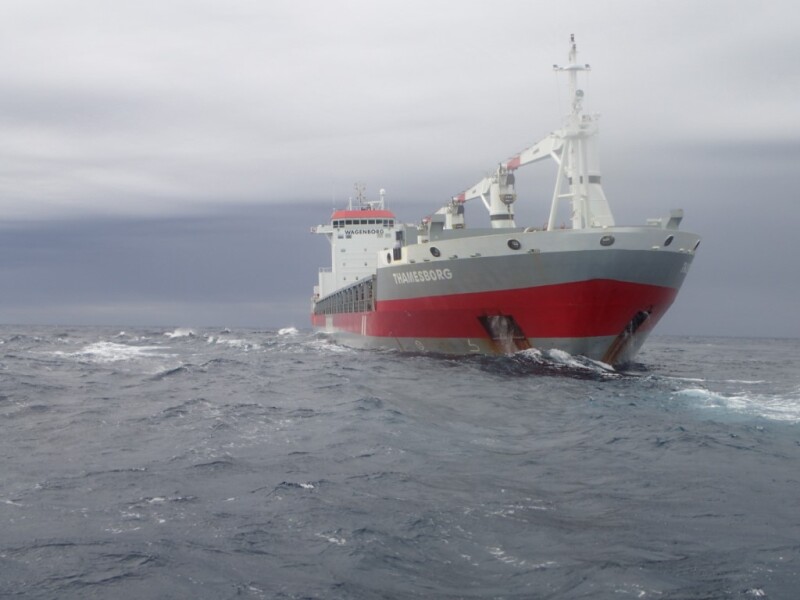
In September 2025, the grounding of the general cargo ship Thamesborg in the remote Franklin Strait is a stark reminder of the persistent danger. The investigation is ongoing, but it occurred ina notoriously challenging waterway in the Canadian Arctic, where charts are widely acknowledged to contain insufficient information.

The Thamesborg incident highlights a broader challenge in the Arctic: the full picture of groundings and their causes may be obscured by the region’s remoteness, complicating investigations.. The foundational UNCLOS framework is being tested by competing claims, the Polar Code’s effectiveness is constrained by a lack of fundamental data, and the pace of hydrographic surveying is critically outmatched by the rapid increase in shipping traffic. The reliance on century-old data poses an unacceptable risk, as evidenced by recent groundings. The same factors driving increased access—climate change and economic interest—are also creating the conditions for a major maritime disaster.
The Arctic's transition from a frozen frontier to a viable trade route will only be truly safe and sustainable if the international community moves from a reactive posture to a proactive and unified approach to governance, infrastructure, and environmental stewardship. The challenges of navigating the new Arctic are a test of the international community's ability to prioritize long-term safety and environmental protection over short-term economic and geopolitical gain.
Michelle Levano is a uniformed officer who has operated federal research vessels in the Arctic Circle, Great Lakes, and throughout the EEZ of the United States. The views expressed are those of the individual and not those of the Department of Commerce, NOAA, or the NOAA Corps.