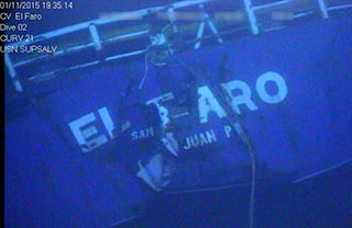
Early hopes that Capt. Michael Davidson and the crew of the El Faro could reach safety were dashed as Coast Guard rescue coordinators were unable to raise the ship’s satellite telephone, and realized its last known position was close to the center of Hurricane Joaquin.
“I’d say I was very alarmed,” Petty Officer 2nd Class Matthew Chancery, who was on duty in the Coast Guard Seventh District command center on the morning of Oct. 1, told the marine board of inquiry in Jacksonville, Fla., Wednesday.
Chancery had seen an email about the 790’ ro/ro containership with 33 on board losing propulsion enroute from Jacksonville to San Juan, Puerto Rico, and talked by telephone with John Lawrence, manager of safety and operations for TOTE Services Inc. Lawrence had spoken by satellite phone with Davidson a few minutes before.
In earlier testimony, Lawrence said Davidson had told him of plans to pump out the El Faro’s flooded No. 3 hold, and believed the ship could get underway again. In their conversation, Chancery and Lawrence talked about potential refuges for the ship.
“The position I’m looking at, they should be able to anchor,” Chancery told Lawrence in the recorded call, played for the board. Chancery explained that position looked like the El Faro could reach the Turks and Caicos, islands that would afford some protection from storm waves.
Under that scenario, “for these kinds of situations, where there’s not an emergent situation” with a need to evacuate crew, it would be up to TOTE Services to send commercial assistance, Chancery told the board.
But after failing to reach Davidson by phone, and getting a satellite relay distress signal from the ship, Chancery said it became evident the situation was dire.
“I wanted to know where the ship was in relation to Joaquin,” Chancery said. Plotting from the El Faro’s Automatic Identification System track, “the position I plotted was right in the middle of the hurricane,” he said.
In his 7 a.m. call to Lawrence, Davidson had estimated the ship was listing 15 degrees, with wind out of the northeast and swells 10’ to 12’. As Chancery began to call other ships, he asked them to try calling the El Faro, and asked what conditions they were seeing. One captain reported winds 50 to 60 knots and swells in excess of 20’.
Chancery said he sought assets able to assist the search, including an Air Force Reserve WC-130J Hurricane Hunter aircraft that was monitoring the storm. The nearest Coast Guard cutter, the 210’x34’x10’ Resolute, was several hundred miles away, south of Guantanamo Bay, Cuba, he said.
One email in evidence with the board is from Davidson, outlining his voyage plan to TOTE officials on shore. Davidson wrote he planned to adjust course as the forecasted track of Joaquin swung southwest, aiming to pass 65 miles south of the eye of the storm. He reported making “good progress” and storm preparations.
“I anticipate us being on the back side of her…I have indicated a later than expected arrival time in San Juan,” Davidson wrote. For the return trip, Davidson was planning to take the Old Bahama Channel back north, foreseeing that Joaquin would swing north and up the Gulf Stream.


