


The often-unnoticed work of the U.S. Army Corps of Engineers greatly benefits the public, even though many people don’t realize that their drinking water, the products they use, and their modern way of life depend on it.
A recently completed Corps project to construct an underwater sill in the Lower Mississippi River illustrates the agency’s crucial role in maintaining shipping operations, municipal utilities, industrial activity, and public health along the river system and throughout much of the nation.
STOPPING AN UNDERWATER RIVER
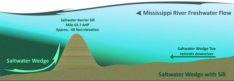
The newly constructed sill is halting saltwater from traveling far upstream from the Gulf of Mexico and contaminating residential and industrial water intakes along the river. This critically needed temporary structure has been built repeatedly by the Corps since the late 1980s and has consistently achieved its purpose while maintaining shipping along the nation’s busiest waterway. The sill is constructed periodically on an as-needed basis and is not intended to be permanent.
When the Mississippi River’s water level drops low enough, saltwater from the Gulf flows upstream along the riverbed beneath the freshwater moving downstream. This dense saltwater moves upriver in a wedge-shaped flow that can extend about 20 miles. When the leading edge of the saltwater wedge reaches predetermined locations in the river, the Army Corps initiates construction of the underwater sill to halt further intrusion.

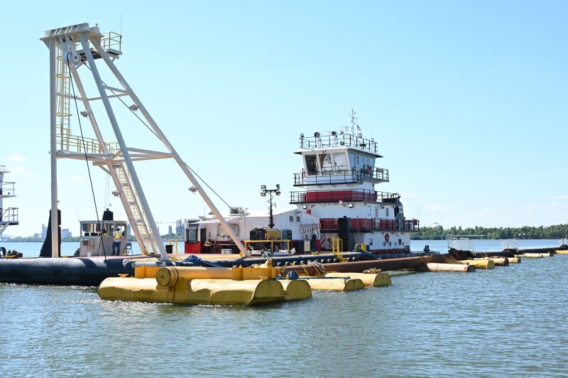
Constructed over two weeks in late September and October near Myrtle Grove, La., in Plaquemines Parish, the underwater barrier reduces the risk of saltwater infiltrating freshwater intakes along the river. Completed in October, the sill was built using sediment from nearby areas designated for that purpose. Approximately 50 employees from the emergency response team at the Corps’ New Orleans District office worked on the project.
The temporary sill is maintained by the Corps for as long as it is needed and is allowed to erode naturally once its purpose has been served — typically when downstream river flow increases enough to push saltwater back toward the Gulf. The sill effectively creates an underwater basin that temporarily captures and holds much of the saltwater in place.
Another reason for the sill’s location is that it lies downriver from the municipal water treatment plant in Belle Chasse, La., the southernmost large-scale municipal facility on the river. If the sill holds the saltwater wedge at bay, there should be no impacts to Belle Chasse or to locations farther upriver.
“There are smaller water treatment facilities downstream of Belle Chasse that are impacted by saltwater intrusion, but the local parish government has made improvements over the last few years to combat saltwater intrusion, so we have not been tasked with undertaking additional efforts this year. Previously, those efforts included placement of reverse osmosis water purification units at, and barging of water to, those facilities,” said Matt Roe, a public affairs specialist for the Corps’ New Orleans District.
The Mississippi Valley drains 41% of the contiguous United States and two Canadian provinces. In recent years, reduced rainfall across the valley has led to drought conditions and the need to construct underwater sills.
SEASONAL PROBLEM, PERENNIAL SOLUTION
Saltwater intrusion in the Mississippi River is possible because the river’s bed lies below sea level from the Gulf of Mexico to Natchez, Miss.
Under normal flow conditions, the river’s freshwater volume prevents significant upriver movement of saltwater. When flows are extremely low, however, monitoring river salinity becomes critical.
“We start monitoring the location of the toe of the saltwater wedge once river flows are below 400,000 cubic feet per second. Construction of the underwater sill is trigger based, so once those triggers are hit, we know it is time to construct the underwater sill,” said Roee.
The Corps maintains close coordination with local officials to monitor salinity levels and to implement measures such as constructing a sill when necessary.
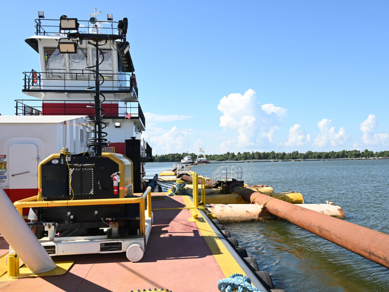
“Construction of the sill only takes about two weeks, but it takes about two weeks before that for mobilization of a contract dredge with all the supporting equipment,” Roe said. “The local parish water treatment facilities measure salinity on a daily basis.
“We share information regularly about conditions we are seeing, our efforts, their efforts, and whether any assistance is needed.”
The effectiveness of the sill becomes apparent almost immediately once construction begins. “As soon as the dredge starts placing material, we see benefits from construction of the underwater sill,” he said.
The sill remains in place until river flows increase to higher levels.
The most recent construction marks the seventh time over the past few decades that the Corps has built an underwater sill near Myrtle Grove. Similar sills were constructed there in 1988, 1999, 2017, 2022, 2023, and again in 2024. The underwater sill also supports the Corps’ effort to increase the depth of the river’s shipping channel to 50', helping to ease navigation and commerce.
The Corps first became involved with managing saltwater intrusion following the deepening of the Mississippi River ship channel in the 1980s.
“The Mississippi is naturally deep between Head of Passes and Baton Rouge, La., where the ship channel ends,” Roe said. Ninety-five miles below New Orleans, Head of Passes is considered to be the mouth of the River.
“The Corps maintains Southwest Pass and 12 crossings, where the ship channel moves from one bank to the other, but other than that, the river does not need dredging to maintain the ship channel. The river at Algiers Point, near the French Quarter, for example, is about 190 feet deep. The location where we build the sill in the river is about 90 feet deep,” Roe said. The sill functions as an underwater levee.
“The river bottom at the sill location ranges from minus-90 feet on the ship channel side to minus-70 feet on the other side,” he said. “Sediment is placed across the bottom of the river to a depth of 55 feet. The height of the sill ranges from 15 to 35 feet, depending on which side of the river you’re on. The depth of 55 feet allows deep draft navigation to continue on the river with minimal impacts.”
In 2023, the sill was overtopped, and forecasts indicated that river levels would continue to fall, allowing the saltwater wedge to move farther upriver and potentially affect water treatment facilities in the greater New Orleans area, Roe explained. During that event, the Corps raised the sides of the sill to minus 30' while leaving a 620' wide notch at the original minus 55' depth to allow deep-draft navigation to continue.
“This approach was successful, and the saltwater wedge did not reach the greater New Orleans area. Right now, we do not know if this approach will be needed during this event. It is an option if conditions do not improve. However, an augmented sill was not required during the low-water event last year,” Roe said.