(Bloomberg) — The Atlantic hurricane season is less than three weeks old yet it’s already threatening the energy-rich Gulf of Mexico coastline.
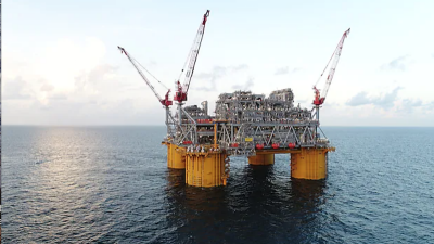
Tropical systems in the Gulf of Mexico often grab the notice of energy traders because the Texas and Louisiana coastline is home to offshore rigs and platforms accounting for about 17% of U.S. crude oil output and 4.1% of natural gas production. They can lead to the evacuation of non-essential personnel from rigs and platforms, cause power outages and also disrupt shipping.
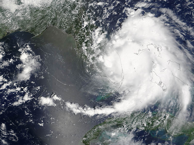
A potential system in the Gulf of Mexico sparked tropical storm warnings on Louisiana’s coastline and watches from High Island, Texas, to Intracoastal City, Louisiana. Tropical Storm Bret, which formed Monday, prompted similar warnings in Trinidad and Tobago, Grenada and parts of Venezuela, according to the U.S. National Hurricane Center in Miami. That stretch along the Gulf Coast includes Sabine Pass, site of the only active U.S. liquefied natural gas export plant, operated by Cheniere Energy Inc. High Island isn’t far from the mouth of the Houston Ship Channel, which leads to the Port of Houston, where more than 241 million tons of cargo are moved through each year.
To have two storms in the Atlantic in June is a bit out of the ordinary.
“It is unusual but not unprecedented,” said Bob Henson, a meteorologist and blogger with Weather Underground in Boulder, Colorado. “Both will affect land.”
The system about 325 mi. south of the mouth of the Mississippi River has been labeled a “potential tropical cyclone” by the hurricane center. That designation is new this year and follows improvements in forecasting.
The biggest threat from the storm will be heavy rain along the U.S. Gulf Coast, said Dan Pydynowski, a senior meteorologist at AccuWeather Inc. in State College, Penn. There are upper level winds that could push the heaviest rain away from its center, which he said could probably come ashore anywhere from the Texas-Louisiana border to the Florida Panhandle.
No one should discount the damage these rains can do, Henson said. One forecast model predicted Monday at least 6 to 10 inches of rain could fall across a large portion of the Gulf Coast with some pockets getting as much as 20 inches.
“The last time that happened it was a major disaster,” Henson said.
Bret, with top winds of 40 miles per hour, was about 30 miles from Trinidad, according to an 11 p.m. New York time advisory from the hurricane center.
“This storm is unusually far south, the center may go right over Trinidad and Tobago tonight,” said Pydynowski. “There will be several inches of rainfall, wind gusts from 40 to 50 miles per hour tonight and early tomorrow.”
It’s rare for a storm to threaten Trinidad, the biggest supplier of liquefied natural gas to Engie SA’s Everett import terminal in Massachusetts. Trinidad exported about 10 million tons of LNG last year, according to the International Group of LNG Importers, about 4% of the global trade.
“There have only been four in the last 150 years that we know about,” Henson said. “The only hurricane that has formed was the Trinidad hurricane of 1933.”
Henson said chances are its luck will run out in the next few days. It will enter a section of the Caribbean often called the “graveyard of storms” where it will be torn apart, he said.
The hurricane center predicts it will fall apart in three days.
While it’s hard to predict what the rest of the year will bring based on early activity, these storms could be indicators of a busy Atlantic season, Henson said. An average season produces 12 named systems of at least tropical storm strength.
Bloomberg News by Brian K. Sullivan