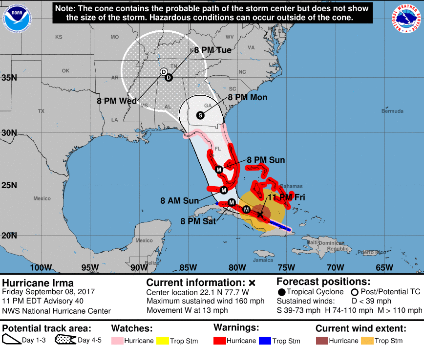
Coast Guard officials declared the first Florida port shutdown at Key West Friday morning, as category 5 Hurricane Irma continued an approach that could put its winds on both of the state’s coasts.
The port condition Zulu at Key West followed escalating precautions from Miami to Savannah, Ga., as National Hurricane Center forecasters projected the hurricane will most likely track up the spine of the Florida peninsula through Monday morning. Tropical storm force winds were expected in the Keys before 8 a.m. Saturday.
“It’s not a question of if Florida’s going to be impacted, it’s a question of how bad Florida’s going to be impacted,” said William, ‘Brock’ Long, administrator of the Federal Emergency Management Agency, said at a Friday news briefing.
Anticipating a potential loss of marine radio transmissions during the storm, the Coast Guard on Friday evening set up a dedicated telephone line for mariners in need of assistance during life-threatening emergencies only. Mariners should first attempt to contact local responders through 911, and if unavailable, call the Coast Guard Sector Miami incident command post at (305) 953-4617.
At 6 a.m. Friday port condition Yankee was set for Port Canaveral on the Atlantic coast, and at noon for Port Miami, Miami River, Port Everglades, Port of Palm Beach, Port of Fort Pierce and all other South Florida terminals and facilities, with winds of 39 and 54 mph possible within 24 hours.
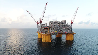
That closed the ports to commercial traffic and transfers, and a warning from the Coast Guard that “there are no safe havens in these facilities.” All deep-draft oceagoing vessels and barges greater than 500 tons were directed , and ports are safest when the inventory of vessels is at a minimum. All ocean-going commercial vessels and ocean-going barges greater than 500 gross tons were directded to start making plans for departure.
The Port Canaveral Lock and all other operations shut down at 3 p.m., port officials said. Cruise ship departures had already been cancelled through Sept. 10.

Lt. j.g. Matthew Humphrys, an MH-60 Jayhawk helicopter pilot at Coast Guard Air Station Clearwater, prepares to evacuate Friday, Sept. 8, 2017 in preparation for Hurricane Irma. Coast Guard photo/PO1 Miichael De Nyse)
The Coast Guard followed its own advice as well, moving Florida-based cutters and aircraft to safe locations so they can quickly redeploy to begin recovery operations. Eight helicopters, four fixed-wing aircraft and their crews were pre-staged from Clearwater, Fla., to the New Orleans air station to ensure they would be in action as soon as the storm passes. Two C-130 Hercules transport crews had already evacuated Coast Guard personnel in the Caribbean, said station commander Capt. Edward Sandlin.
Mariners were warned also to clear any intracoastal passages early, where drawbridges will be locked down for evacuations and sustained winds over 25 mph. A day after Miami-Dade County officials began evacuations for Miami Beach, Collier County on the other side of the state urged people to leave the southwestern coastal communities of Everglades City, Goodland and Marco Island, and other warnings were issued farther up to Gulf coast to Tampa.
As it moved westward at about 11 knots toward the north coast of Cuba, Irma showed some oscillation in its central pressure around 925 millibars, before returning to category 5 strength late Friday with sustained wind intensity around 140 knots. The storm moved over waters with ocean surface temperatures of 87 degrees Fahrenheit. The hurricane will maintain its strength, and “only unpredictable eyewall replacement cycles could result in intensity fluctuations during the next 24 hours,” NHC forecasters reported.
That could bring storm surges of 8’ to 12’ to the Keys and south Florida coasts, and total rain accumulations of 8"’ to 15"’ with up to 20” in isolated areas through Tuesday night, the NHC forecast. Early next week Irma will bring heavy rain with potential for flash flooding to Georgia, South Carolina and western North Carolina.

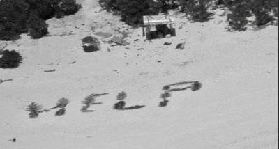
A Coast Guard aircrew surveyed St. Thomas harbor areas after Hurricane Irma. Coast Guard video still/PO1 Luke Clayton
In the wake of Irma’s earlier path, the Coast Guard began opening some island ports Thursday evening, with San Juan, P.R., reopened without restriction along with Ponce and others, while Guayama and Mayaguez reopened with some restrictions. Culebra and Arecibo remained closed.
In the U.S. Virgin Islands, all of St. Thomas, Cruz Bay in St. John, and Fredericksted at St. Croix remained closed. Coast Guard officials urged all mariners to abide by the closings. Vessel operators seeking to transport supplies or people to those area. will not be allowed to enter until all port and facility assessments have been completed and deemed safe for vessel traffic by the captain of the port San Juan.
"We understand the desire to assist people impacted in St. Thomas and St. John, U.S. Virgin Islands, said Capt. Eric King, U.S. Coast Guard Captain of the Port San Juan. "At this time port conditions in these areas remain unsafe for vessel traffic, and people who choose to disregard port condition warnings could make a bad situation worse."
In Texas, port recovery continued amid the cleanup from Hurricane Harvey. The Coast Guard established electronic Aids to Navigation to aid in the reopening of Port Aransas, creating 13 virtual eATON after completing channel and waterway assessments.
The eATONs can be used on any AIS-equipped radar or electronic charting system to temporarily mark waterways where buoys and beacons were lost or destroyed. The eATON were broadcast over the Coast Guard’s Nationwide Automatic Identification System, and contributed to the port opening several days ahead of schedule, Coast Guard officials said.
As a back up to the Nationwide AIS network, the Coast Guard also deployed a portable AIS system to Texas for Hurricane Harvey. This portable system provides the ability to broadcast eATON in areas where Nationwide AIS does not cover.
“As demonstrated during this hurricane response, eATON enables us to quickly mark a waterway on a temporary basis while our traditional physical aids to navigation are reconstituted following a natural disaster,” said Chief Warrant Officer Kristopher Franklin of the Coast Guard Navigation Technology and Risk Management Division.