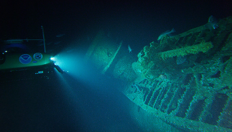
An expedition to map an underwater World War II battlefield off Cape Hatteras, N.C., has produced striking imagery of the sunken U-boat U-576 and Nicaraguan-flagged freighter Bluefields.
Both vessels were lost July 15, 1942, in a convoy skirmish that marked one encounter in the protracted “Battle of the Atlantic,” the longest continuous military campaign in World War II pitting German and Italian naval vessels against Canadian, British and U.S. forces defending Allied merchant ships ferrying supplies and equipment.
The National Oceanic and Atmospheric Administration and partners embarked on a mission last month to document the wrecks as part of a larger project involving nationally significant shipwrecks in the “Graveyard of the Atlantic” off North Carolina’s Outer Banks. That trip concluded Sept. 6, and researchers returned with the first images of the forgotten vessels.
The wrecks of the Bluefields and U-576 had been lost to history after the war. In 2014, NOAA discovered the vessels 35 miles offshore and approximately 700 feet underwater — just 240 yards apart.
“This discovery is the only known location in U.S. waters that contains archaeologically preserved remains of a convoy battle where both sides are so close together,” said Joe Hoyt, Monitor National Marine Sanctuary archaeologist and chief scientist for the expedition. “By studying this site for the first time, we hope to learn more about the battle, as well as the natural habitats surrounding the shipwrecks.”
The Bluefields and U-576 were placed on the National Register of Historic Places last year, and NOAA is considering expanding the National Marine Sanctuary around the wreck of the famed Civil War ironclad USS Monitor to increase protections for these two wrecks and others.